By Roselyn Fauth
In South Canterbury, weather is more than small talk, Timaru weather can turn fast. Remember that day when we had both the countries high and low... I think we hit 41 degrees, and by 4pm the southerly roared in and our mercury thermometers plummeted to 14! while that was extreme, we can often start the morning thinking it is barbecue weather, then by afternoon a stiff southerly has arrived and everyone is hunting for jerseys. Crowded House had it right with "Four Seasons in One Day". That can feel very real here.
Most of us learn to read the sky a bit. We notice a nor’west arch. We watch for rain clouds. We feel the wind start to turn. We see a front coming before the forecast tells us. But reading the sky only gets you so far.
For simple tasks like hanging out the washing, and planning for some home DIY, to shipping, farming, preparing for droughts, floods, wind, snow, sweltering heat or a hard frost, better weather information matters. A forecast gives us more warning and time to plan for what might be coming.
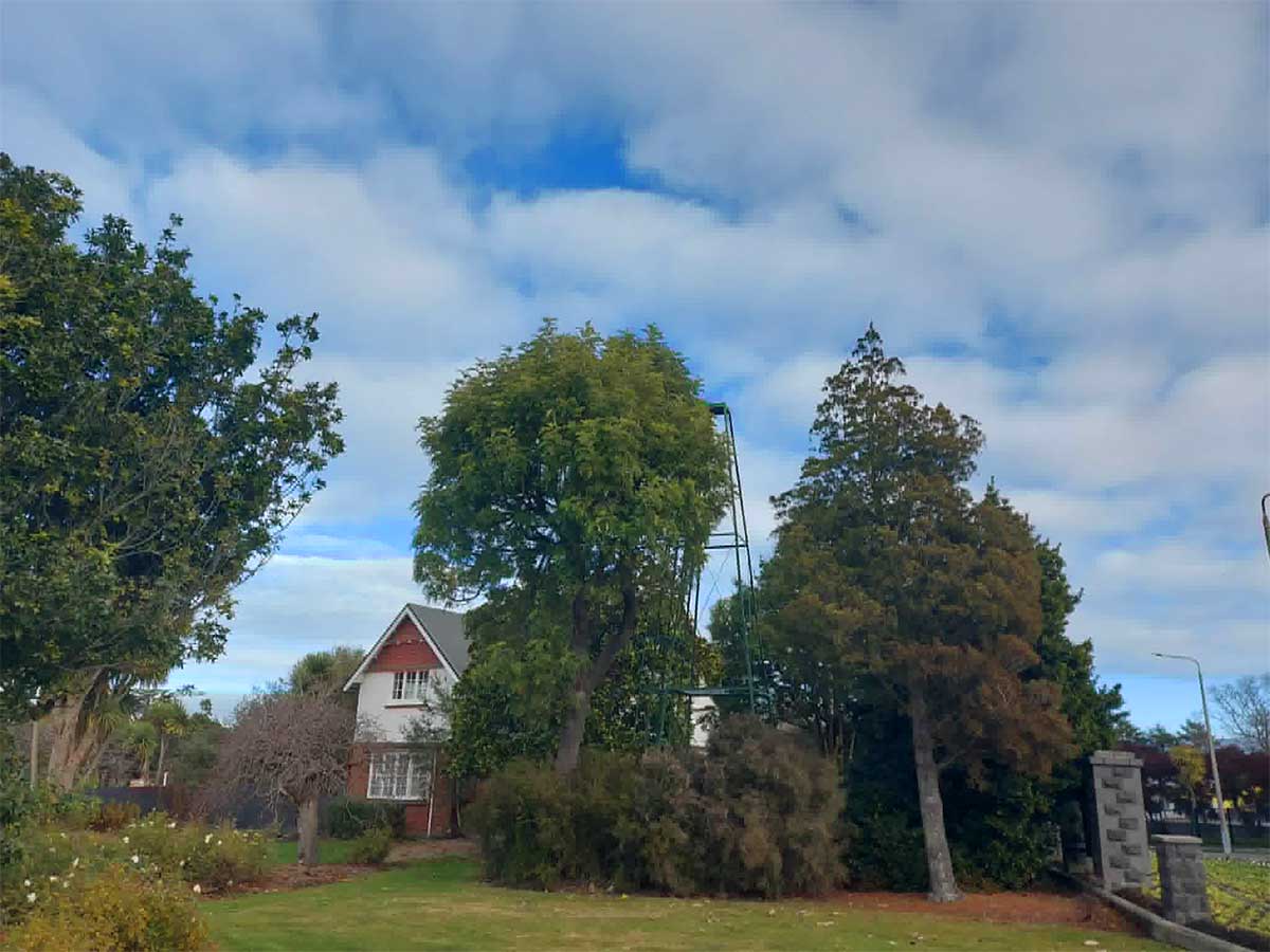
So perhaps it should not surprise us that the Timaru Botanic Gardens has a weather station. When we recall this, we probably think its the white structure on the lane verge, the fenced-off Met station, but you probably didn't realise each time you drove through the garden gate, there was a weather reading old-looking steel tower to the West. It stands near the former caretaker’s house, tucked among trees. It is not decorative like the rotunda or gate or fountain.. this built bit of heritage was there for a practical job.
So I asked the obvious question. What was it for? Well alot more than I realised... today's blog is all about how Timaru was asking to be part of the national weather-recording network, how today's sophisticated forecasting we rely on wasn't created overnight — it was built on the methodical work of observers in places like Timaru.

Memories pointed to sunshine recording
After having a hunt through Timaru history and local memories, I found comments from people sharing what they knew about the tower.
Several remembered it as part of the old weather-recording equipment. More than one person remembered climbing the tower, changing a card, and recording sunshine hours. Others remembered a glass ball, a special card, a scorch mark, and the daily job of replacing the paper. One memory also mentioned wind measuring equipment.

So here is my hunch... I wonder if the tower once had a glass ball on or near the top, a piece of prepared card underneath, and regular foot traffic from someone climbing up to change the card and record the hours of sunshine.
I do not yet have a plan or official record proving exactly what was mounted on the tower. So I do not want to overstate it... but the memories are important because they describe a very specific instrument and a very specific routine. I think it is pretty plausable that the tower may have remembered sunshine, and the instrument people were describing sounds like a Campbell-Stokes sunshine recorder.
This was a clear glass sphere that acted like a strong magnifying glass. Behind it sat a curved card that would be scorched by the sun through the glass to mark the sunshine strength with the hours of the day. If cloud covered the sun, the burn stopped. At the end of the day, the card was removed and the burnt trace was measured. So rather than the tower predicting the weather, it helped us remembered it.
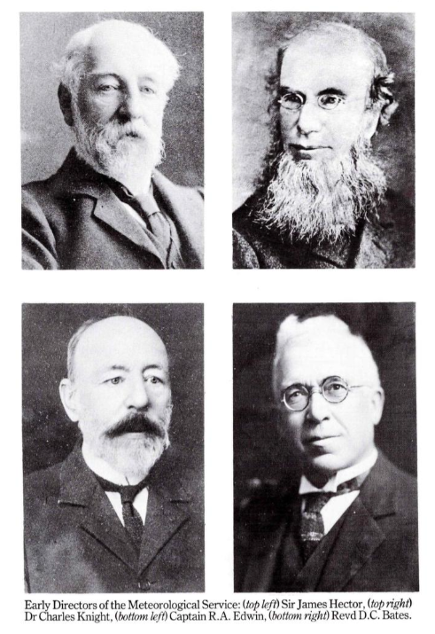
I started with the MetService website to see what weather history I could find and learned that New Zealand’s official meteorological story began on 21 August 1861, when Dr Charles Knight was appointed the first Director of Meteorological Stations. Ten permanent meteorological stations were established that year, making the New Zealand Meteorological Service the country’s oldest continuous scientific institution. By 1867, 26 telegraph stations were exchanging regular weather reports, and in 1874, after a spate of shipwrecks, a storm-warning system and the first public weather forecasts were established under Commander R. Edwin. Forecasting remained strongly tied to marine safety for many decades.
1860–1861 Colonel Mould proposed a colonial network of observing stations, including Lyttelton and “some inland post at the foot of the Southern Alps.” In 1861, instrument sets were sent to Lyttelton/Christchurch as part of the new national scheme.
1861 Dr Charles Knight became Director of Meteorological Stations. De Lisle marks 1861 as the beginning of organised official meteorological observations in New Zealand and therefore the start of the present Meteorological Service.
In 1861 the Colonial Secretary of New Zealand, William Fox, wrote to the superintendants of various Provences through out New Zealand instructing them to establish observitories to house meteorological instrucments which the Colonial Office would send them. Each province was to appoint someone to record instrumental readings twice a day, note details of the weather and send results at intervals to central Government for collation. The summarised information would enable Meteorological Statistics of New Zealand to be published from time to time. Dr Charles Knight, the Auditor General, was appointed to control the scheme and soon after was signing correspondence as Director of Meteorological Stations. The year 1861 marks the start of organised official meteorological observations in New Zealand and of the present New Zealand Meteorological Service, thus making the Service the oldest scientific institution in the country. ... - Sails to satellites : a history of meteorology in New Zealand 1986
By July 1860, fourteen cases of instruments had arrived in Auckland and were stored in the Queen’s Warehouse, a board of enquiy was established to work out what had happened, unfortunately they were all broken. A year later the replacement instruments arrived. In 1861, nine sets of instruments were sent out — to New Plymouth, Napier, Wellington, Nelson, Picton, Lyttelton (from where Julius von Haast was directed to collect them and bring them safely to Christchurch), Dunedin and Christchurch.
1862–1863 Wellington’s observatory began twice-daily observations. John Knowles already imagined a system like Britain’s storm-warning service once electric telegraphy became available.
1865–1866 The Electric Telegraph Act gave central government control of telegraphy, and Parliament agreed in 1866 to use the telegraph service for shipping news and weather reports. The first telegraph line had opened between Lyttelton and Christchurch three years earlier.

Meteorological stations 1867. Local weather was recorded at 9 a.m. at telegraph offices, and the messages sent to all telegraph offices and displayed at ports. By 1869, New Zealand’s meteorological stations and observers included R. B. Gore at Wellington, C. Rous Marten at Southland, Henry Grover at Mongonui, H. Knight at Napier, Thomas Kirk at Auckland, Henry Clouston at Nelson, William Northcroft at Taranaki, Henry Skey at Dunedin, R. Mainwaring at Christchurch, John Rochfort at Hokitika, and J. M. Munce at Bealey. By the end of the year, daily reports were being received from seventeen stations: Auckland, Castlepoint, Timaru, Manukau Heads, Wellington, Oamaru, Thames, Hokitika, Port Chalmers, Coromandel, Westport, Bluff, Taupo, Bealey, Queenstown, Opunake, and Lyttelton. - Sails to satellites : a history of meteorology in New Zealand 1986
1869 Local weather was being recorded at 9 a.m. at twenty-six telegraph offices and distributed to ports. But harbourmasters and seamen were unhappy with reliability, partly because telegraph clerks had other duties.
May 1874 Commander R. A. Edwin began experimental storm warnings from the Custom House in Wellington. He became New Zealand’s official weather forecaster.
1881 Sir James Hector reorganised meteorological work so New Zealand had one Meteorological Department. There were 37 stations reporting at 9 a.m., warnings were telegraphed to coasts expecting dangerous winds or heavy seas, and weather telegrams were exchanged with Sydney. He was a Scottish-born scientist: geologist, naturalist, surgeon, explorer and administrator. He was born in Edinburgh in 1834, came to New Zealand in the 1860s, first for geological survey work in Otago, and then became one of the most powerful organisers of colonial science in Wellington.
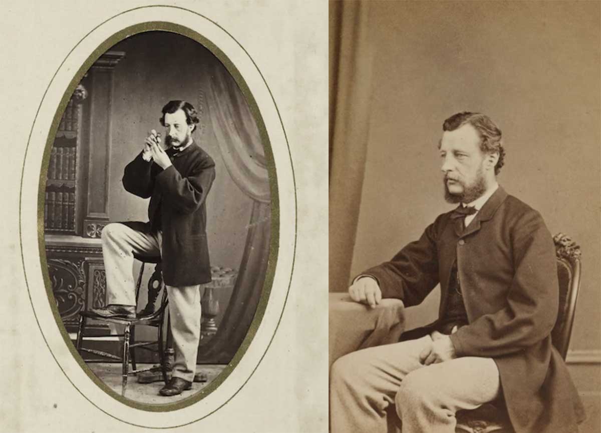
LEFT: Studio portrait of Sir James Hector - Photograph taken by John McGregor Dunedin. RIGHT: Sir James Hector, 1868-1874, Wellington, by James Wrigglesworth. aged about thirty-four. It was taken around the time he was appointed director of both the Geological Survey and the Colonial Museum (Te Papa's predecessors). At various times Hector was responsible for the New Zealand Institute, the Meteorological Department, the Colonial Observatory, the Wellington Time-Ball Observatory, the Botanic Garden of Wellington, and was the custodian of the standard weights and measures and the Patent Office library. An extremely influential figure in colonial science, Hector received many honours in his life time, including a knighthood in 1887. Purchased 2001 with New Zealand Lottery Grants Board funds. Te Papa (O.042733)
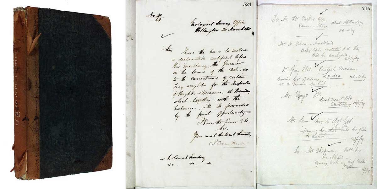
Outward letterbook 1865-1870 by Colonial Museum. Includes Sir James Hector letters. CC BY-NC-ND 4.0. Te Papa (MU000013/001/0001) https://collections.tepapa.govt.nz/object/238399
With a bit of Googling I found the name of this device, which then led me to a paperspast article!
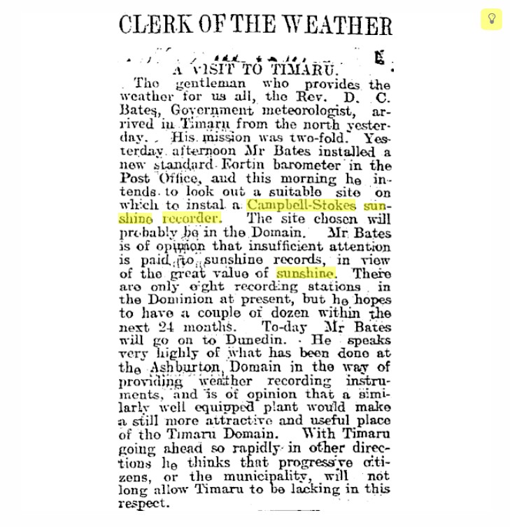
CLERK OF THE WEATHER Timaru Herald 10 September 1913 Page 4.
A VISIT TO TIMARU. The gentleman who provides the weather for us all, the Rev. D. C. Bates, Government meteorologist, arrived in Timaru from the north yesterday. His mission was two-fold. Yesterday afternoon Mr Bates installed a new standard Fortin barometer in the Post Office, and this morning he intends to look out a suitable site on which to install a Campbell-Stokes sunshine recorder. The site chosen will probably be in the Domain. Mr Bates is of opinion that insufficient attention is paid to sunshine records, in view of the great value of sunshine. There are only eight recording stations in the Dominion at present, but he hopes to have a couple of dozen within the next 24 months. To-day Mr Bates will go on to Dunedin. He speaks very highly of what has been done at the Ashburton Domain in the way of providing weather recording instruments, and is of opinion that a similarly well-equipped plant would make a still more attractive and useful place of the Timaru Domain. With Timaru going ahead so rapidly in other directions, he thinks that progressive citizens, or the municipality, will not long allow Timaru to be lacking in this respect.
This is a fantastic find and confirmed:
- 1897 – Weather records begin in Timaru (Mr Cameron, Wai-iti Road).
- 1909 – Records move to the Botanic Gardens (from the Botanic Gardens sign).
- This newspaper article (likely c.1910) – Rev. D. C. Bates personally visits Timaru to choose a site for a Campbell-Stokes sunshine recorder, expecting it to be installed in the Domain (the Botanic Gardens/Domain area).
- 1934 – Sunshine hours are appearing regularly in the Timaru Herald.
- 1936 – The site is described as a Government Meteorological Station.
- Late 1960s–early 1970s – Local people remember climbing the tower to change the sunshine cards.
- Today – The Met station still operates, while the old tower survives nearby.
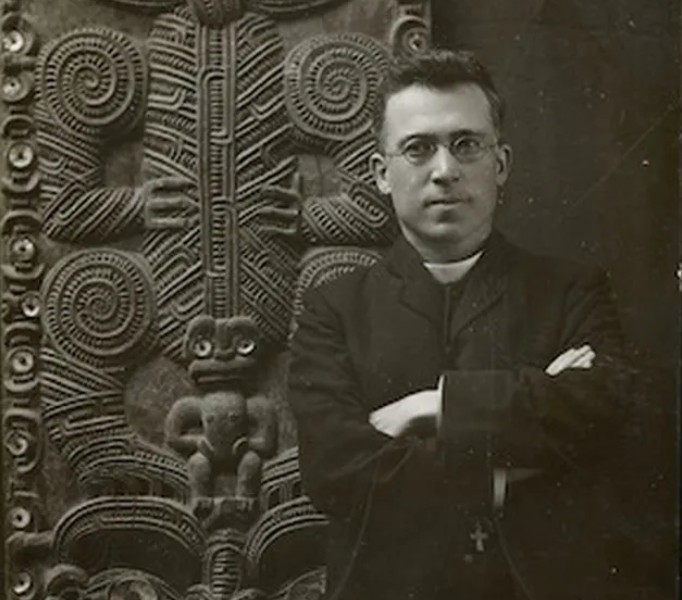
Reverend Daniel Cross Bates. Ref: 1/2-C-028321-F. Alexander Turnbull Library, Wellington, New Zealand. /records/23199692
Rev. Daniel Cross Bates (1868–1954) was one of the most important figures in the history of New Zealand meteorology. Bates was the Government's leading meteorologist and would go on to head New Zealand's Meteorological Office.
Born in Spalding, Lincolnshire, England, he was ordained as an Anglican minister in Australia in 1892 before moving to New Zealand in 1898 to become vicar of All Saints' Church in Invercargill. After serving as a chaplain during the South African (Boer) War, ill health led him to leave parish ministry and join the Colonial Museum in Wellington in 1903, where he turned his attention to climatology and weather observation. From 1909 to 1927 he served as New Zealand's Chief Government Meteorologist, travelling extensively throughout the country establishing and improving weather stations, encouraging communities to install standard instruments and collect reliable observations.
His visit to Timaru was part of this nationwide effort. In 1920 he published Climate and Meteorology of New Zealand, one of the country's foundational works on weather and climate, and after retiring he continued to serve as the Government's consulting meteorologist. During his visit to Timaru, he inspected the town, installed a new Fortin barometer and set out to choose a site for a Campbell–Stokes sunshine recorder—probably in the Domain.
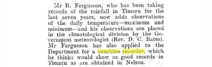
Mr R. Ferguson, who has been taking records of the rainfall in Timaru for the last seven years, now adds observations of the daily temperature—maximum and minimum—and his observations are placed in the climatological division by the Government meteorologist (Rev. D. C. Bates). Mr Ferguson has also applied to the Department for a sunshine recorder, which he thinks would show as good records in Timaru as are obtained in Nelson. Timaru Herald, Volume XC, Issue 13179, 9 January 1907, Page 5
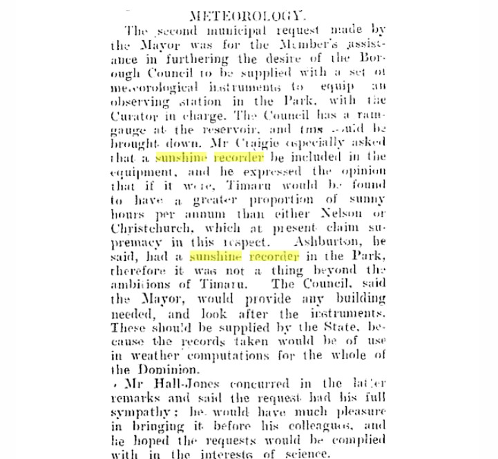
The second municipal request made by the Mayor was for the Member's assistance in furthering the desire of the Borough Council to be supplied with a set of meteorological instruments to equip an observing station in the Park, with the Curator in charge. The Council has a rain-gauge at the reservoir, and one could be brought down. Mr Craigie especially asked that a sunshine recorder be included in the equipment, and expressed the opinion that if it were, Timaru would be found to have a greater proportion of sunny hours per annum than either Nelson or Christchurch, which at present claim supremacy in this respect. Ashburton, he said, had a sunshine recorder in the Park; therefore it was not a thing beyond the ambitions of Timaru. The Council, said the Mayor, would provide any building needed, and look after the instruments. These should be supplied by the State, because the records taken would be of use in weather computations for the whole of the Dominion. Mr Hall-Jones concurred in the latter remarks and said the request had his full sympathy. He would have much pleasure in bringing it before his colleagues, and he hoped the request would be complied with in the interests of science.
. Timaru Herald, Volume XIIC, Issue 13528, 25 February 1908, Page 2
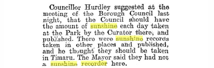
Councillor Hurdley suggested at the meeting of the Borough Council last night, that the Council should have the amount of sunshine each day taken at the Park by the Curator there, and published. There were sunshine records taken in other places and published, and he thought they should be taken in Timaru. The Mayor said they had not a sunshine recorder here. Timaru Herald, Volume C, Issue 15367, 9 June 1914, Page 6

The Mayor mentioned at last night's meeting of the Timaru Borough Council, that Mr A. Leslie had very kindly offered to provide a sunshine recorder for the Borough of Timaru. Timaru Herald, Volume XCVIII, Issue 18084, 23 September 1924, Page 6

...They would be pleased to hear that Mr Bates had decided to place a sunshine recorder in the Park." TIMARU BOROUGH COUNCIL Timaru Herald 28 July 1914 Page 5

Mr F. J. Rolleston, M.P., wrote stating that he had been able to secure a sunshine recorder for use in Timaru Park. It was decided to thank Mr Rolleston. Timaru Herald, Volume XCVIII, Issue 18084, 29 October 1924, Page 9

"Park sunshine recorder.—The chairman reported that the sunshine recorder had been received and that Mr Bates would visit Timaru to-morrow to fix the site." - BOROUGH COUNCIL. Timaru Herald, Volume XCVIII, Issue 18084, 23 December 1924, Page 7 https://paperspast.natlib.govt.nz/newspapers/THD19241223.2.14?end_date=31-12-1945

The sunshine recorder at Timaru Park shows that during January, there was a total of 182 hours 32 minutes of sunshine, an average of 5 hours 53 minutes a day. There were four sunless days during the month.. Timaru Herald 3 February 1925 Page 6 https://paperspast.natlib.govt.nz/newspapers/THD19250203.2.17?end_date=31-12-1945
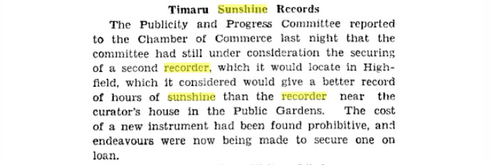
Local and General News Timaru Herald, Volume CXLV, Issue 21148, 22 September 1938, Page 6 https://paperspast.natlib.govt.nz/newspapers/THD19380922.2.30?end_date=31-12-1945
This article reports that Timaru’s Publicity and Progress Committee was looking for a better site for the town’s sunshine recorder. The committee wanted to move it to Highfield, believing it would give a better record of sunshine hours than the existing recorder near the curator’s house in the Public Gardens. However, the cost of a new instrument was considered too high, so the committee was trying to secure one on loan. This is important because it confirms that, by 1938, Timaru’s sunshine recorder was located near the curator’s house in the Public Gardens. That fits closely with the tower’s location and strengthens the link between the tower, the Gardens weather station, the curator, and sunshine recording.
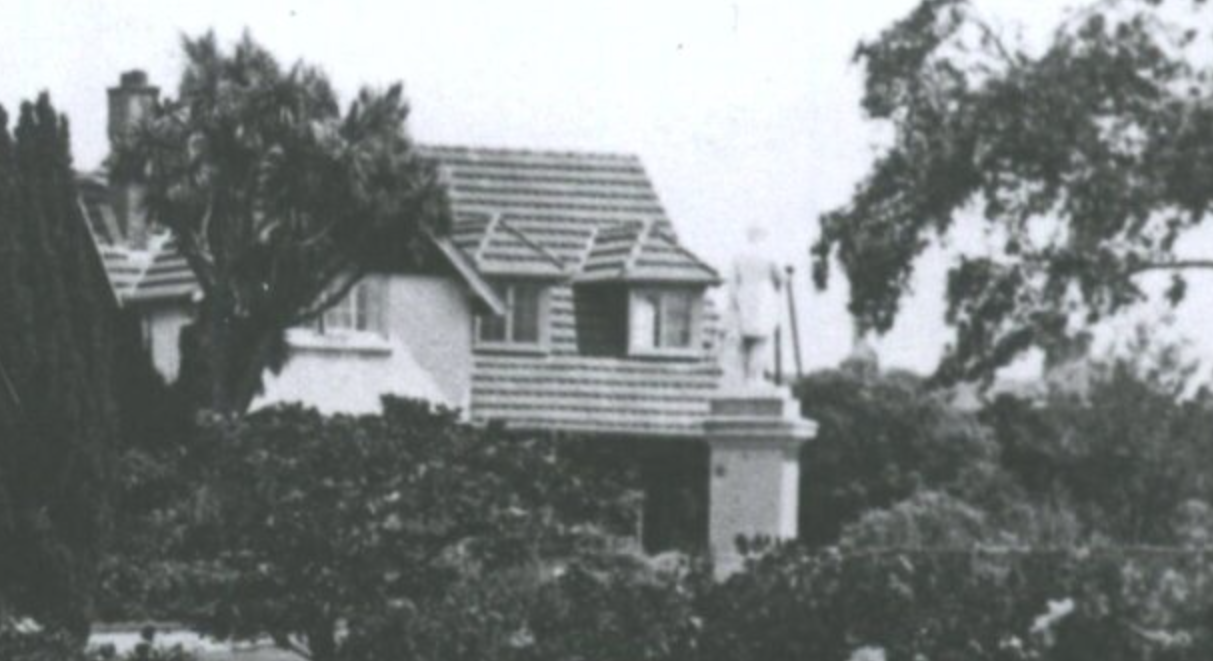
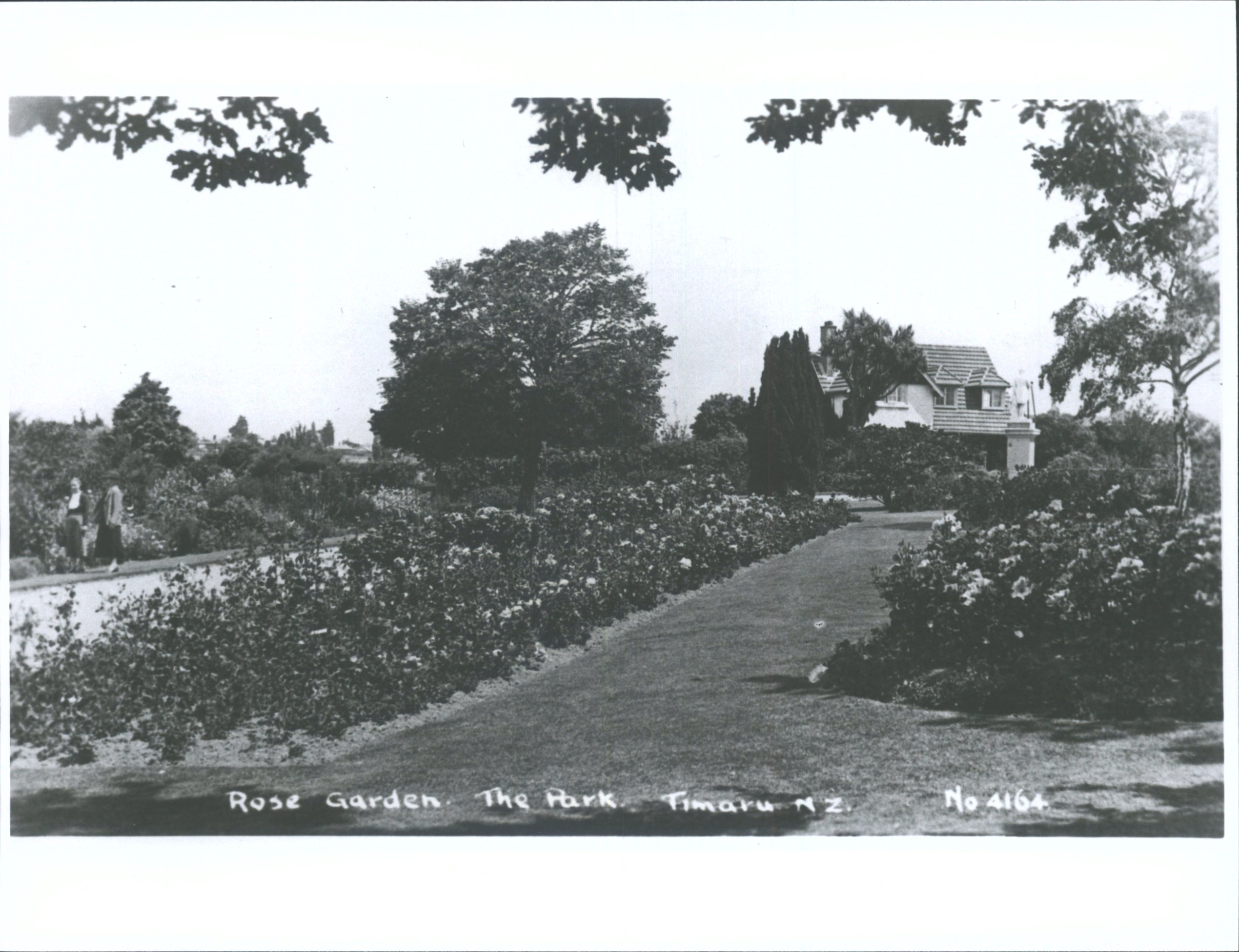
A detail in the Rose Garden confirms the tower location, The Park, Timaru, N.Z.. Hocken Digital Collections, https://hocken.recollect.co.nz/nodes/view/24154
The newspaper reports prove that Timaru Park/Botanic Gardens had official weather recording, a sunshine recorder, and a recorder site near the curator’s house. Local memories then connect the surviving tower with the later task of changing sunshine cards. What remains unproven is when the tower was built and whether it was the original mounting structure for the recorder.
Timaru’s sunshine-recording story can now be traced from local observers and Borough Council requests in the early 1900s, through the Government Meteorologist’s decision to place a recorder in the Park in 1914, to published sunshine figures by 1925 and official Government Meteorological Station status by 1936. The surviving tower is not yet fully proven as the original recorder structure, but local memories strongly connect it with the later daily work of changing sunshine cards.
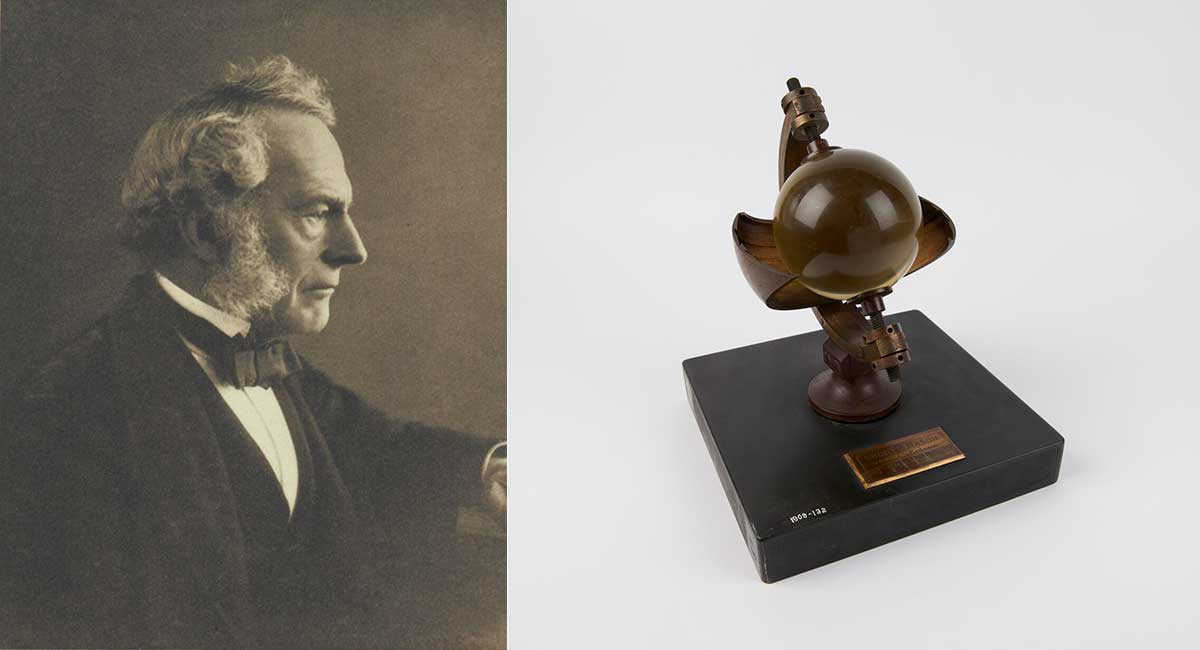
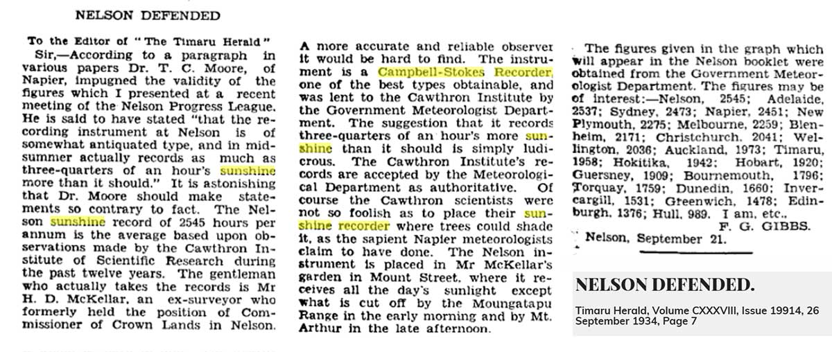
LEFT: George Gabriel Stokes, ante 1903 - public domain. RIGHT: Campbell-Stokes sunshine recorder (sometimes called a Stokes sphere) by Short and Mason. Science Museum Group
The instrument had a big scientific backstory
The original sunshine recorder was devised in 1853 by John Francis Campbell. Campbell was born in Edinburgh in December 1821 and spent much of his childhood on Islay in the Inner Hebrides. He was interested in natural science, photography and optics, which helps explain why he was thinking about light, lenses and the heat of the sun.
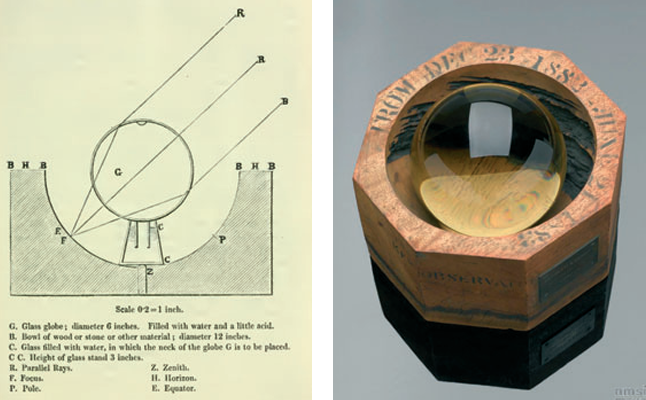
His first sunshine recorder used a glass sphere filled with water set into a wooden bowl. The sun’s rays were focused through the sphere and scorched the bowl, leaving a record of sunshine.
In 1857, Campbell replaced the water-filled lens with a solid glass sphere.
In 1880, Sir George Gabriel Stokes improved the design. He replaced the bowl with a metal semi-ring with grooves to hold daily cards behind the glass sphere. This made the recorder more practical for everyday meteorological use.
The improved design became known as the Campbell-Stokes sunshine recorder and, from the 1880s, became the most commonly used device for measuring hours of bright sunshine across much of the world.
That matters for Timaru because the memories of the tower match this instrument closely: the glass sphere, the card, the scorch mark, and the daily reading. It means this was not a quirky local gadget. It was part of an internationally recognised way of measuring sunshine.
LEFT: First sunshine recorder design (Campbell, 1857). RIGHT: Modified version including a glass sphere, with the wooden bowl used from 23 December 1882 to 21 June 1883 at Kew Observatory (© Science Museum Group, Object Number 1995-818, http://collectionsonline.nmsi.ac.uk/.)
The bigger weather story began long before anyone climbed the tower due to a run of shipwrecks in 1861.
In 1861, after a run of shipwrecks around New Zealand, the Government established a storm-warning service within the Marine Department. For many years, forecasting was closely tied to shipping. It was not about deciding whether to hang the washing out. It was about keeping ships, cargo and people safer. Three years later, in 1864, Timaru Botanic Gardens were established.
A local Gardens history book written by the late Keith Bartholomew says a climatological station was established at Timaru Park in 1909.
Later climate work appears to treat Timaru Gardens as a long-running rainfall and climate observation site from around 1910 onwards.
From measuring the daily changes, the tower is part of progress to have long weather records.
New Zealand’s Meteorological weather service was changing in the mid 1920s.
In 1926, forecasting became part of the newly formed Department of Scientific and Industrial Research. The following year, Edward Kidson was appointed Dominion Meteorologist.
At that time, the New Zealand Meteorological Service was still small, with a staff of five and a shortage of useful long-period meteorological records.
Weather records are built slowly, from repeated observations taken in places like Timaru, day after day, year after year. By the 1930s, sunshine, rainfall, temperature, wind and pressure were being treated as measurable climate information. Timaru was not just talking about the weather. It was helping measure it.
Long before scientific instruments arrived, people already observed the weather here through close attention to the sky, sea, wind, birds, plants and seasons. The meteorological station was one later system of observation, added to a landscape where careful weather knowledge already mattered.
A Timaru Herald article discusses a meeting of the Timaru High Schools Board of Governors, covering a range of school matters including the search for a new Lady Principal at Timaru Girls’ High School, prize donations from the South Canterbury branch of the New Zealand Society of Accountants, laboratory funding for Timaru Boys’ High School, rugby ground arrangements, accounts, and school grounds decisions. Of interest to the weather story, the Education Department approved a grant of £65 for permanent laboratory apparatus at Timaru Boys’ High School, but declined funding for several additional items including a barograph, sunshine recorder and Fortin barometer. The article shows that by 1923, professional weather-measuring instruments were considered useful educational equipment in Timaru, even if the school had not yet secured funding for them.
https://paperspast.natlib.govt.nz/newspapers/THD19230918.2.8?end_date=31-12-1945
From 1935 Timaru Herald weather records were being published from Timaru Gardens.

THE WEATHER Timaru Herald 10 January 1934 Page 6 https://paperspast.natlib.govt.nz/newspapers/THD19340110.2.61
On reading through past newspaper articles about the Gardens recording weather, I found out that in 1934 the Timaru Herald started publishing the sunshine recordings.
By January 1934, the Timaru Herald was publishing sunshine figures for Timaru. One report said 9.2 hours of sunshine had been recorded on the Monday, bringing the total for the year to 43.7 hours.
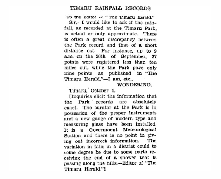
By the mid-1930s, the paper was publishing fuller weather observations from Timaru Gardens. These included barometer readings, grass minimum temperature, frost, wind, rainfall, maximum temperature and sunshine hours.
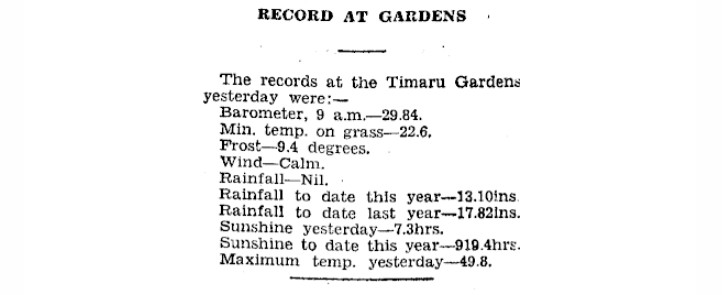
Nelson sunshine hours defended - NELSON DEFENDED. Timaru Herald, Volume CXXXVIII, Issue 19914, 26 September 1934, Page 7
This 1934 letter defends the accuracy of Nelson’s sunshine records and explains that its Campbell-Stokes recorder was supplied by the Government Meteorologist Department. It shows that sunshine recording was taken seriously, that instrument placement mattered because trees or hills could shade the recorder, and that sunshine totals were being compared between places in New Zealand and overseas. Timaru appears in the comparison list with 1,958 annual sunshine hours, showing that Timaru’s sunshine record was part of a wider network of comparable weather data.
Timaru Herald, Volume CXXXX, Issue 20169, 25 July 1935, Page 2 https://paperspast.natlib.govt.nz/newspapers/THD19350725.2.6
Then came the line that changed the story when a reader of the Timaru Herald of 3 October 1936 questioned rainfall figures.
The response said the Park records were “absolutely exact”. It said the curator at the Park had proper instruments, and that a new modern rain gauge and measuring glass had been installed. This news report confirmed that the Timaru Botanic Garderns was officially part of a Government Meteorological Station network with instruments in the care of the curator." Great to find this report as now I can hang my hat on this fun fact and get a bit closer to validating my hunch.
TIMARU RAINFALL RECORDS Timaru Herald 3 October 1936 Page 18 https://paperspast.natlib.govt.nz/newspapers/THD19361003.2.109.1
By 1936, Timaru’s sunshine records were being studied, not just reported
An article in the Timaru Herald , "Sunny Timaru", 12 August 1936), shows that Timaru's weather records were much more than daily observations—they were being analysed, compared and used to better understand the district's climate. Written by a Timaru Boys' High School geography class, it demonstrates how local weather data had become an educational resource, with students interpreting years of sunshine records rather than simply reporting them. The article compares Timaru's average sunshine with other centres around New Zealand and overseas, explains how sunshine records are calculated, and reminds readers that weather averages are built over many years. It also highlights an important lesson that still applies today: one exceptional summer does not define a climate. By the mid-1930s, Timaru's weather observations were already contributing to a much bigger picture of New Zealand's climate and helping people understand how their local weather compared with the rest of the world. https://paperspast.natlib.govt.nz/newspapers/THD19360812.2.24?end_date=31-12-1945
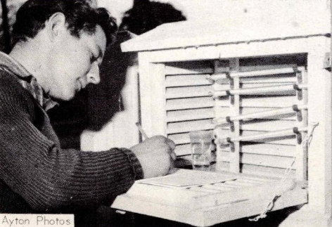
1963 Murray Horrell taking temperature recordings - Mid & South Canterbury foto news https://archive.org/details/mid-sth-canterbury-foto-news-vol-2-no-9
Timaru's weather station was part of a much bigger story.
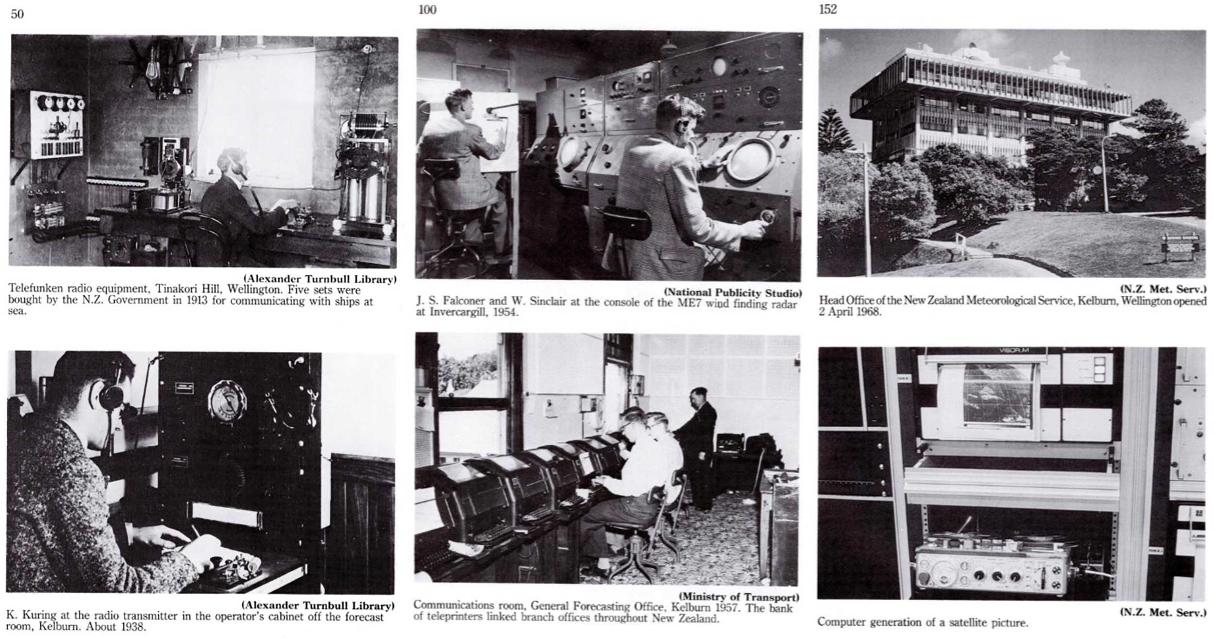
As New Zealand's meteorological service evolved, so too did the way weather was observed and forecast. In 1936, the service became part of the newly formed Department of Scientific and Industrial Research (DSIR). During the Second World War it transferred to the Royal New Zealand Air Force, reflecting the growing importance of weather forecasting for aviation. Later it became part of the Civil Aviation Department and then the Ministry of Transport. In 1992, the service was divided into two organisations: NIWA, responsible for weather and climate research, and MetService, responsible for operational forecasting and public weather services. Today's network of automatic weather stations, weather radar, satellites and powerful computer models is built on more than 160 years of observations—made possible by generations of people who carefully read rain gauges, changed sunshine cards and faithfully recorded the weather each day.
Timaru's weather records were valuable enough to be studied in schools
This article, "Sunny Timaru" (Timaru Herald, 12 August 1936), was written by a Timaru Boys' High School geography class and shows that, by the 1930s, Timaru's weather records were being analysed, interpreted and used as an educational resource—not simply collected and published. Using official meteorological records averaged over several years, the students compared Timaru's annual sunshine with other centres in New Zealand and overseas, explained why long-term averages are more meaningful than a single good or bad summer, and explored which months were typically the sunniest and dullest. They found that Timaru ranked 17th out of 21 New Zealand sunshine-recording stations, averaging 1,958 hours of bright sunshine each year. The article reminds us that weather records were already helping people understand local climate, challenge popular perceptions, and compare Timaru with the wider world—demonstrating just how valuable careful, long-term weather observations had become.
Why bother measuring sunshine?
It sounds simple, but sunshine was useful information. It mattered for gardens, glasshouses, shelter planting and frost. It mattered for farmers watching crops, pasture growth, drought and stock conditions. It mattered for understanding evaporation, soil moisture and local climate.
Sunshine also mattered because climate records only become useful when they are measured in the same way, over a long time. One sunny day is just a sunny day. But years of careful sunshine records can show patterns.
That is why the tower story is bigger than one odd structure in the Gardens. It connects Timaru to a wider effort to measure the environment properly, using instruments, routines and records that could be compared with other places.
Weather records needed people, and behind every number was a place, an instrument, a routine and a person. Someone climbed the tower, changed the sunshine card. Someone read the rain gauge. Someone checked the frost. Someone wrote the figures down.
Every weather report starts with someone doing something others may not realise is done, and the tower makes the hidden system visible.
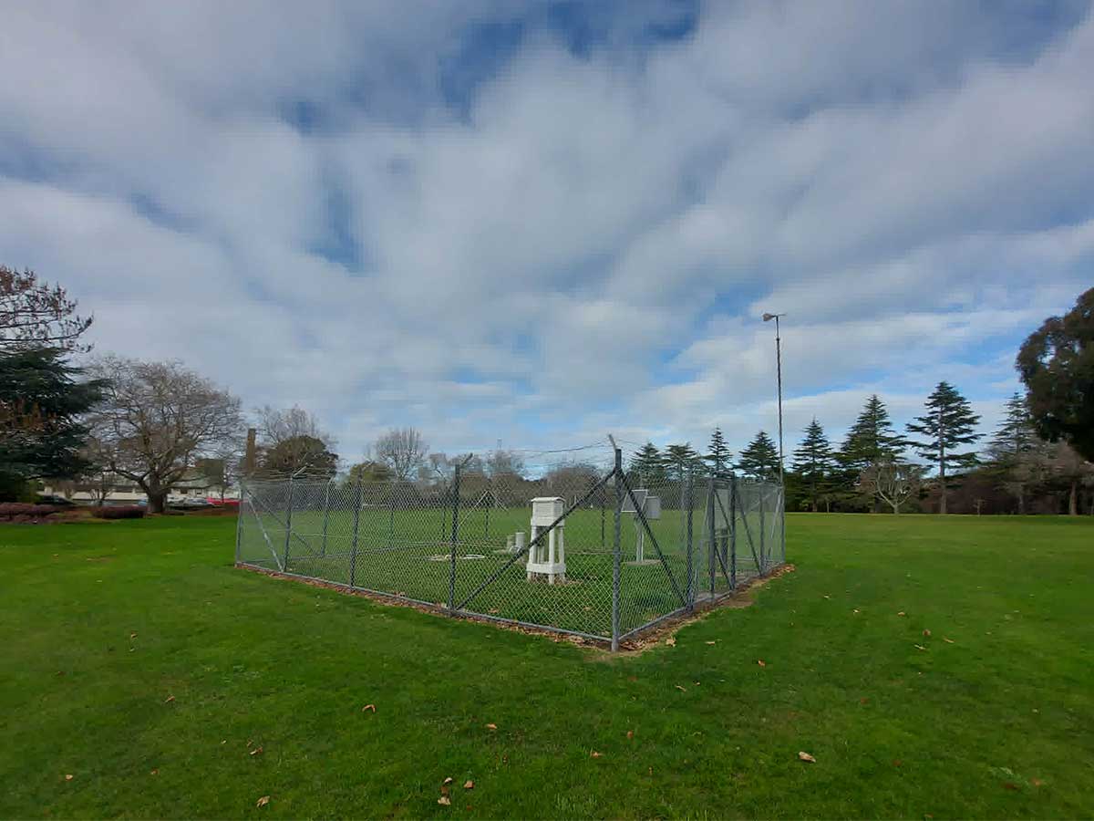
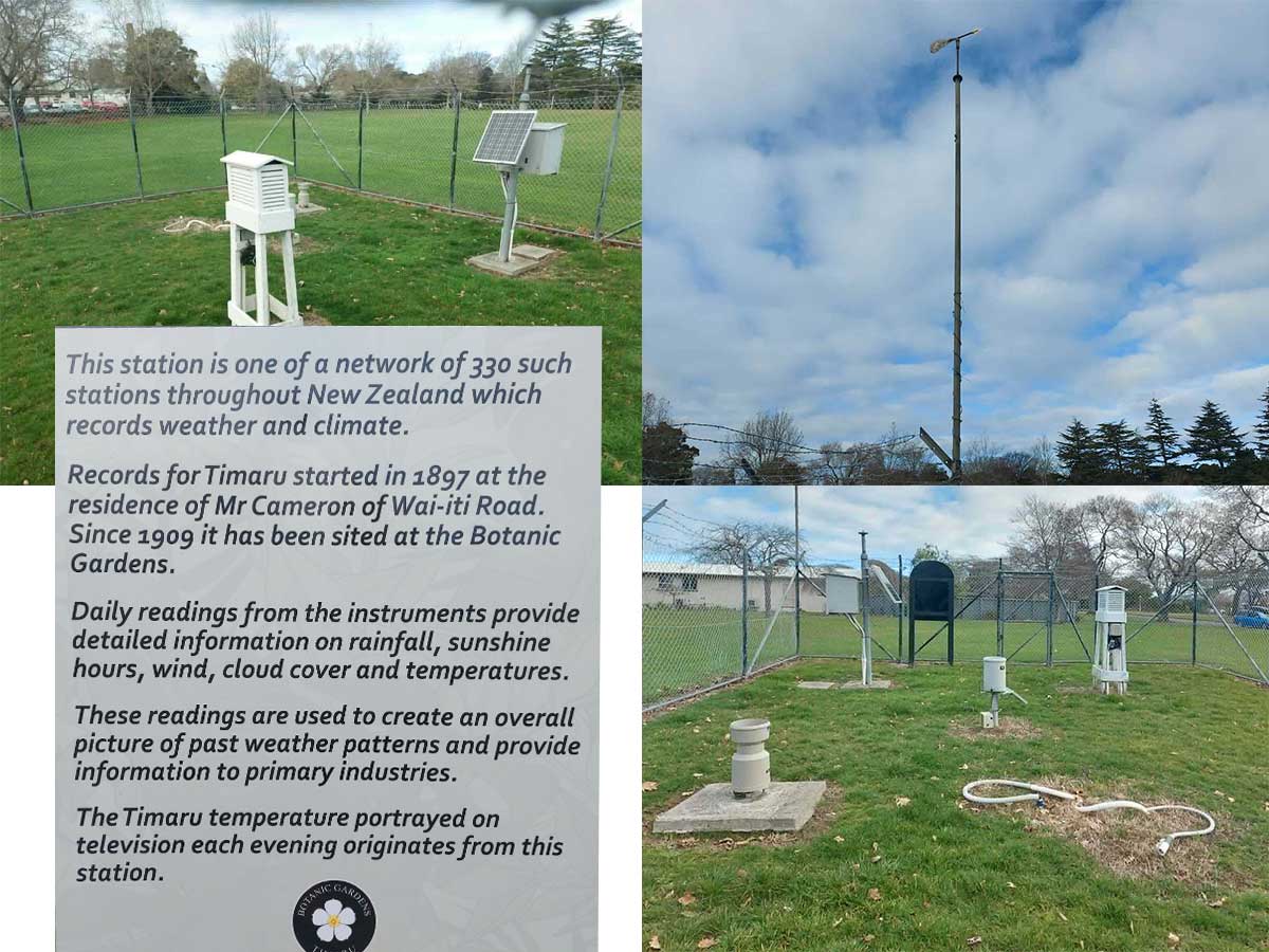
This station is one of a network of 330 such stations throughout New Zealand which records weather and climate. Records for Timaru started in 1897 at the residence of Mr Cameron of Wai-iti Road. Since 1909 it has been sited at the Botanic Gardens. Daily readings from the instruments provide detailed information on rainfall, sunshine hours, wind, cloud cover and temperatures. These readings are used to create an overall picture of past weather patterns and provide information to primary industries. The Timaru temperature portrayed on television each evening originates from this station." - Timaru Botanic Gardens Sign
Weather recording moved on, from 1939, at the outbreak of the Second World War, forecasting became part of the Royal New Zealand Air Force.
Later, it moved through civil aviation and transport departments. In 1992, MetService was established as a state-owned enterprise.
In 1965, the Timaru Herald reported a new weather-recording system at the Timaru Harbour Board lighthouse. That article described newer equipment and also explained a sunshine recorder using a crystal sphere and special cards.
That does not prove the Gardens station ended then. It does show that Timaru’s weather recording was changing by the 1960s, moving into a more modern phase.
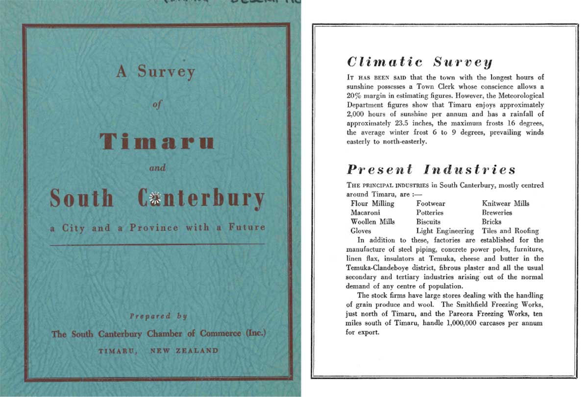
A Survey of Timaru and South Canterbury: a City and a Province with a Future. In 1950, Timaru's population was 21,000. Climatic Survey. IT HAS BEEN SAID that the town with the longest hours of sunshine possesses a Town Clerk whose conscience allows a 20% margin in estimating figures. However, the Meteorological Department figures show that Timaru enjoys approximately 2,000 hours of sunshine per annum and has a rainfall of approximately 23.5 inches, the maximum frosts 16 degrees, the average winter frost 6 to 9 degrees, prevailing winds easterly to north-easterly. - A Survey of Timaru and South Canterbury: a City and a Province with a Future. Aoraki Heritage Collection, accessed 27/06/2026, https://aorakiheritage.recollect.co.nz/nodes/view/1111
Thanks to the comments in the Timaru History and Memories Facebook page, I have access to people's recolletions of climbing the Gardens tower in the late 1960s and early 1970s, changing sunshine cards and recording sunshine hours.
I would love to find out more about this tower, I think it would make a cracker Timaru Herald Civic Trust column.
- Maybe the readers out there can help me confirm when the tower was built.
- If the tower was originally built for the sunshine recorder or for more than one purpose.
What we can say now, is that local memories strongly connect the tower with a Campbell-Stokes sunshine recorder in living memory.
- Newspaper records show that Timaru Gardens was associated with official weather observations by the 1930s.
- In 1936, the site was described as a Government Meteorological Station.
- Later climate work includes long-term observations from Timaru Gardens.
- Today, Timaru District Council’s walking-track information still refers to “The Met station” in the Gardens.
- The tower’s exact origins remain unclear, but it appears to be part of Timaru Botanic Gardens’ wider weather-recording story.
The 3pm temperatures on the national news were always low for Timaru due to the weather site being at the Port. After lobbying from locals the news started reporting temperature from a weather station established in these gardens in 1965, giving Timaru the appearance of warming up overnight!
- Keith Bartholomew, From Waste Land to a Garden of National Significance: Timaru Botanic Gardens 1864–2014.
Go and look up
Next time you are in the Timaru Botanic Gardens, look for the tower. Ask, who climbed it and changed the cards to read the weather?
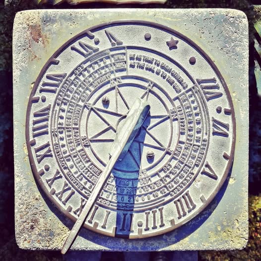
Sundial at the Timaru Botanic Gardens using the sun to tell the time. - Photo Roselyn Fauth
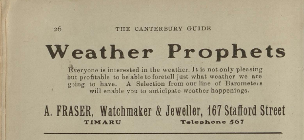
1914. Weather Prophets. Everyone is interested in the weather. It is not only pleasing but profitable to be able to foretell just what weather we are going to have. A Selection from our line of Baromete, will enable you to anticipate weather happenings. A. FRASER, Watchmaker &Jeweller, 167 Stafford Street - Guide to Timaru and Picturesque Canterbury. Aoraki Heritage Collection, accessed 27/06/2026, https://aorakiheritage.recollect.co.nz/nodes/view/8396
Sources and useful leads
Timaru Herald*, 10 January 1934, sunshine recorded in Timaru:
https://paperspast.natlib.govt.nz/newspapers/THD19340110.2.61
Timaru Herald*, 3 October 1936, Government Meteorological Station reference:
https://paperspast.natlib.govt.nz/newspapers/THD19361003.2.109.1
Met Office explanation of Campbell-Stokes sunshine recorder:
https://weather.metoffice.gov.uk/guides/observations/how-we-measure-sunshine
National Museum of the Royal New Zealand Navy, Campbell-Stokes sunshine recorder example:
https://navymuseum.co.nz/explore/by-collections/artefact-unpacked/sunshine-recorder/
Royal Meteorological Society article on the history of the Campbell-Stokes sunshine recorder:
https://rmets.onlinelibrary.wiley.com/doi/full/10.1002/wea.2130
MetService history:
https://about.metservice.com/about-us/our-history
Timaru District Council Botanic Gardens walking track, “The Met station is on the right”:
https://www.timaru.govt.nz/community/recreation/walking-and-cycling/timaru-botanic-gardens
Timaru Botanic Gardens history book reference:
https://www.timaru.govt.nz/news-and-events/latest-news/timaru-botanic-gardens-history-book
Weather is so much more than sunshine, there are some fabulous photos in the South Canterbury Museum online collection of people wworking with and sometimes against the weather.
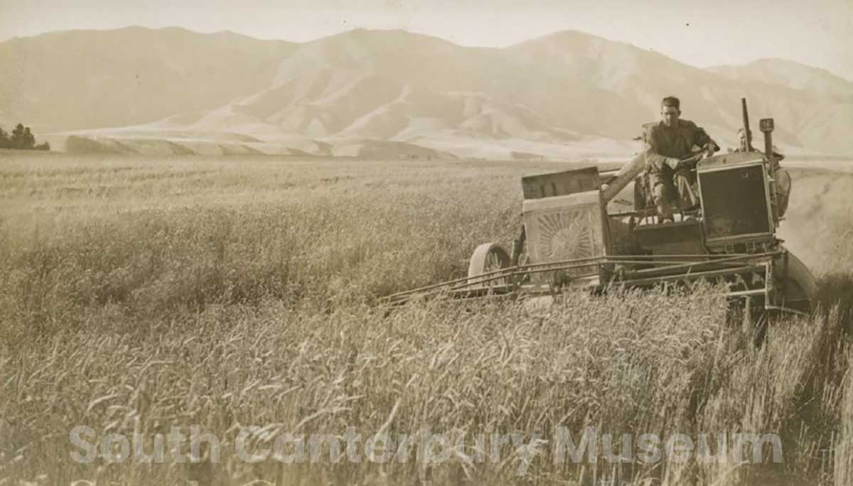
The McCaw Bros Sunshine self-propelled auto header harvesting wheat, circa 1930? Photography by John Logan McCaw. South Canterbury Museum L2014/003.204 https://timdc.pastperfectonline.com/photo/5FF12D6D-D682-4C19-A840-104643446110
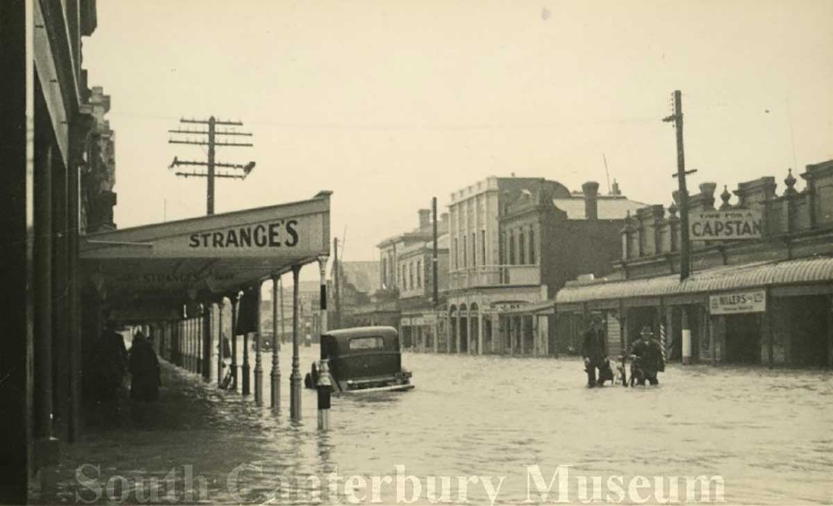
Flooding of King Street, Temuka, in the 1945 flood. Taken looking along the street with a half-submerged car and men wading through the water with bicycle. South Canterbury Museum 3084. https://timdc.pastperfectonline.com/photo/E475D205-1118-45C7-A403-681418893045
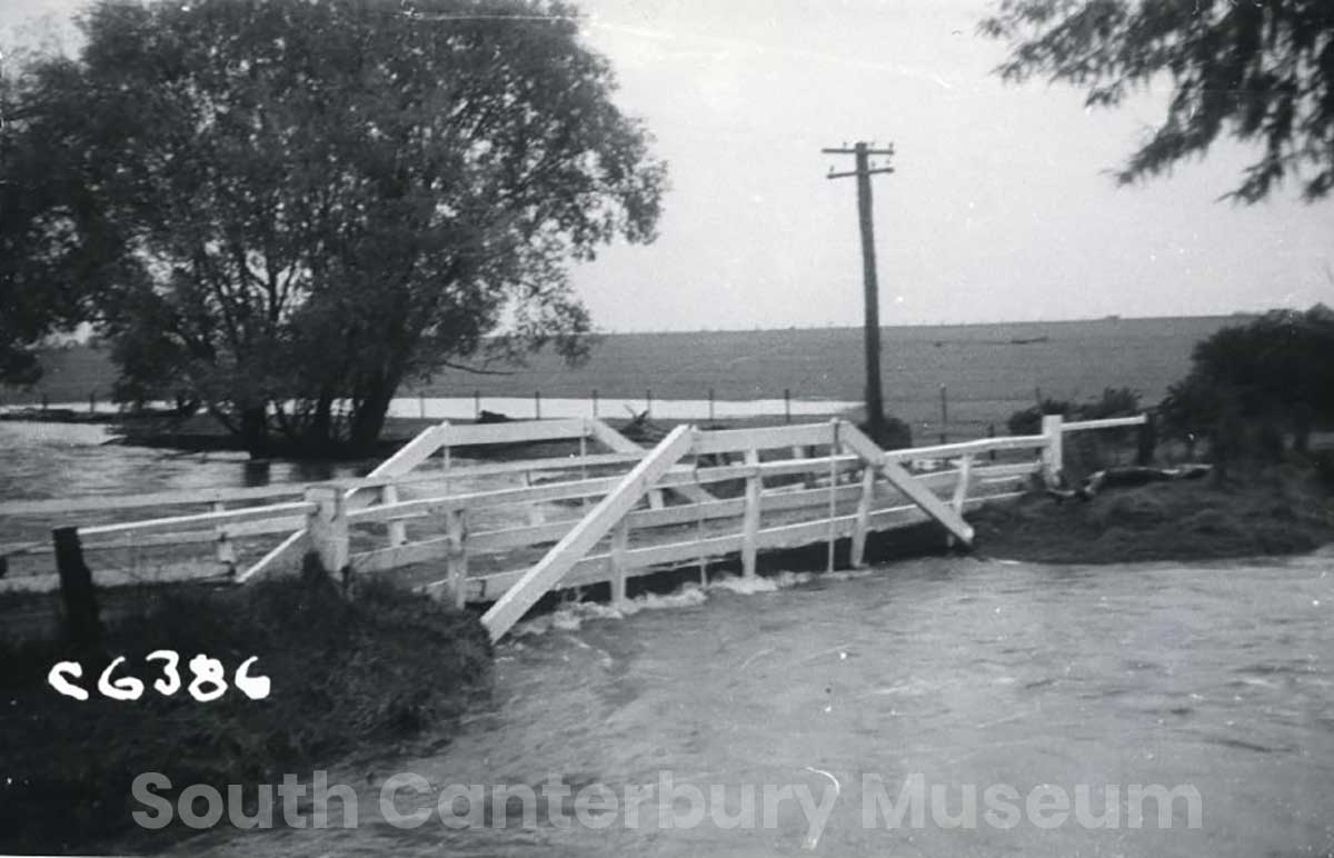
In flood, Sweetwater Creek Bridge in Geraldine 1856 - Ministry of Works Photograph Christchurch - No.71: Geraldine County. Sweetwater Cr. bridge, Bourdens Rd. https://timdc.pastperfectonline.com/photo/A98D1F0C-DDA8-4FAC-BF4F-122572793606
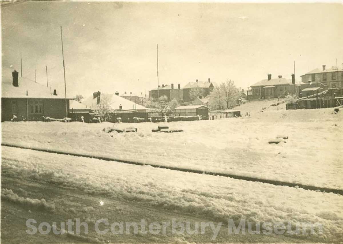
Snow in Timaru, 1945. Snow can look magical in a photograph, but in Timaru it could quickly become serious. The heavy snowfall of 1945 disrupted power, communication, industry and transport — a reminder that weather forecasting was not just useful, but essential. Image courtesy of South Canterbury Museum. South Canterbury Museum, Snow in Timaru, 1945, photograph by Mary Baird, 1945. https://timdc.pastperfectonline.com/photo/0813F4E0-393F-48AC-AE90-566826165716
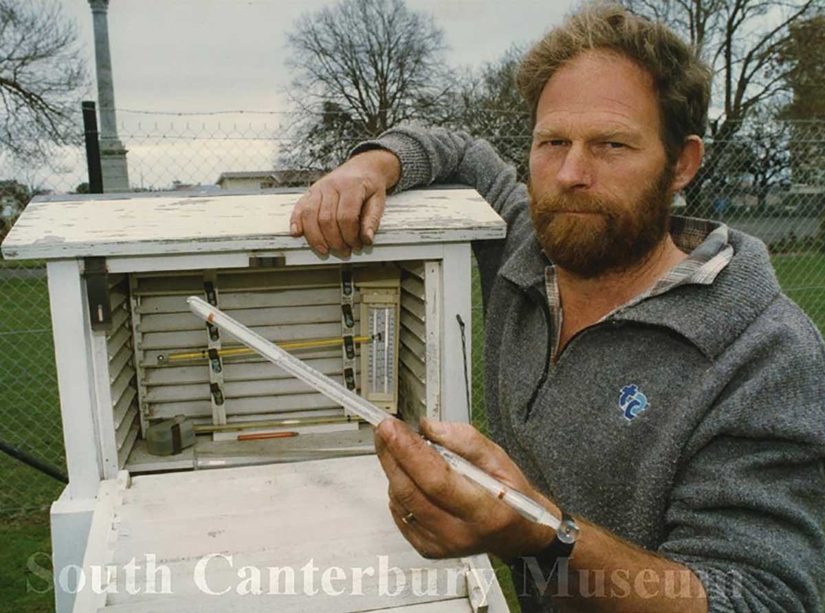
Timaru District Council employee Alistair Davey taking a rain reading at the Timaru Botanical Gardens, dated 17 September 1993. https://timdc.pastperfectonline.com/photo/E2FBEC6B-1B42-4C38-9F93-502301263500

Canterbury Regional Council Flood Contracter Philip Lees, dated 13 August 1997. South Canterbury Musuem https://timdc.pastperfectonline.com/photo/6E7058A1-4204-4FFC-AF8C-323926232344
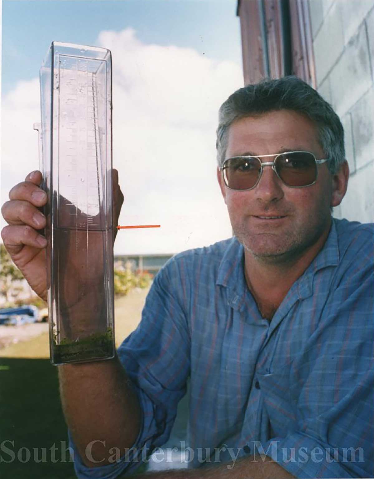
Farmer Warren Darling, of Poplar Grove just south of Timaru, holding a rain gauge, 13 March 1995. Photography By Ron Lindsay Timaru Herald. https://timdc.pastperfectonline.com/photo/DD73206A-8D14-4306-ACC5-044286494554
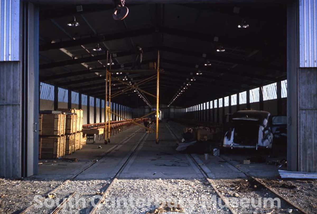
Construction of the all-weather meat loader shed at Timaru Harbour, June 1965. South Canterbury Museum. https://timdc.pastperfectonline.com/photo/E39E44BB-27F3-400A-A80C-295938250834
Please refer to the individual South Canterbury Museum catalogue records for full image details, rights information and reproduction conditions.
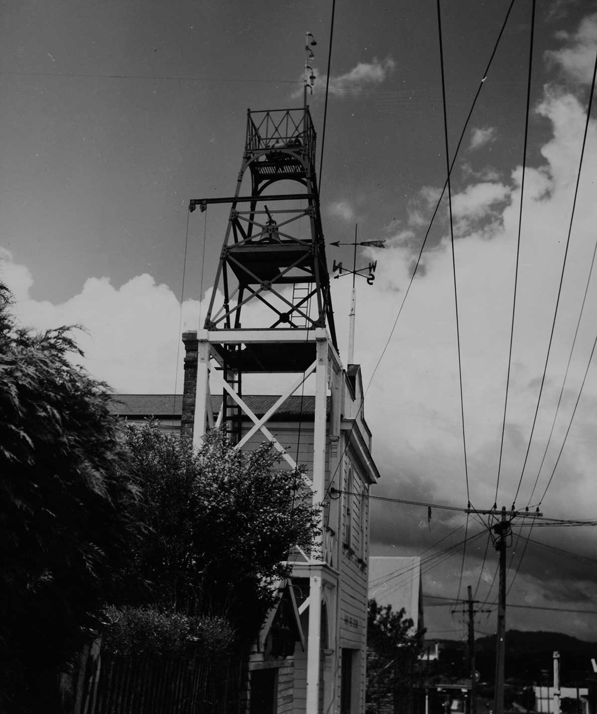
View looking up at a tower located on an street in the centre of the Waihi township, weather measuring devices are in sight atop of this structure. A network of power lines, a hedge row and a line of buildings can be seen at street level here; also featured here (above street level) is a compass (weather pointer).
Side Quest: When Weather Became a Public Safety Mission
New Zealand has been watching the weather closely since the 1840s — but official forecasting began in 1861 after a series of shipwrecks showed just how much lives and livelihoods depended on early storm warnings. At first, forecasting was mainly about the sea. It sat within the Marine Department, helping ships, ports and coastal communities make safer decisions.
Over time, weather forecasting followed the needs of the country. In 1926 it moved into the Department of Scientific and Industrial Research. During World War II, it became part of the Royal New Zealand Air Force, when aviation made accurate forecasting even more urgent. Later it shifted through civil aviation and transport departments.
In 1992, the Meteorological Service of New Zealand Ltd — MetService — became a State-Owned Enterprise. Today it is New Zealand’s longest-standing scientific organisation, using data, science and technology to help people plan, prepare and stay safe. The big idea: weather records are not just numbers. They are a long public-safety story — shaped by shipwrecks, aviation, farming, transport, science, and the everyday need to know what the sky might do next. - https://about.metservice.com/about-us/our-history
Side quest: did Māori watch the weather?
Long before sunshine was measured with a glass ball and a burn card, Māori were watching the weather closely becasue weather shaped travel, fishing, planting, harvesting, shelter, food gathering and survival.
From what I could find out online, Māori read the sky, the wind, the sea, birds, plants, stars, clouds and seasonal patterns. These were known as tohu — signs. A change in cloud colour, the direction of the wind, the behaviour of birds, the look of the sea, or the timing of a plant flowering could all help people judge what was coming. It would be facinating to learn more from our mana whenua.
So while the Campbell-Stokes recorder tells one story (how Victorian scientists tried to measure sunshine in hours) Māori weather knowledge can tell us another. It reminds us that people had already been reading the weather for centuries, not just with instruments, but with attention, memory and relationship to place. Weather history is not only about what was measured. It is also about who was watching, what they noticed, and how that knowledge helped people live well in their place.
Side quest: looking for the women
The official story of the Campbell-Stokes sunshine recorder names the men who invented, tested and improved it — John Francis Campbell, James Glaisher, Robert Scott, William Ellis, George Airy and George Gabriel Stokes.
But it does not name any women.
That does not mean women were absent. It means this account does not put them in the foreground.
The closest connection is indirect, but important. Campbell’s early sunshine measurements were linked to public health after the 1854 London cholera outbreak, when weather, sunshine and urban conditions were being studied in relation to human health. Cholera affected whole communities — including women and children — so this was not just scientific curiosity. It was about understanding the conditions people lived in.
So the side quest is this: who did the quiet daily work? Who changed the cards, copied the records, filed the observations, or helped keep observatory routines going?
The article does not give us their names. But the question is still worth asking, because weather history is not only about instruments and inventors. It is also about the people and communities those measurements were meant to serve.
Side quest: climate change and old records
The Campbell-Stokes sunshine recorder still matters. Campbell designed his first sunshine recorder in 1853, and 160 years later, the article notes that the instrument was still in use. Since the 1880s, it became one of the most commonly used ways to measure hours of bright sunshine across much of the world.
While one sunshine card tells us about one day, thousands of sunshine cards, gathered over decades, help scientists see long-term patterns — not just one hot summer, one gloomy winter, or one strange season.
Historic sunshine records can help researchers understand climate variability and climate change. They are especially useful for studying changes in solar radiation, including “global dimming and brightening” — periods when less or more sunlight reaches the Earth’s surface. They can also help scientists understand aerosols, the tiny particles in the atmosphere that affect how much sunlight gets through.
Today, many Campbell-Stokes recorders have been replaced by automatic sensors. That makes sense for modern weather stations, especially in remote places. But the old records still need to be protected, because changing instruments can create breaks or inconsistencies in long-term data.
A glass ball, a strip of card, and a daily routine became part of a much bigger story — how humans measure change, remember weather, and try to understand what is happening to the planet.
20 fun facts about the Campbell-Stokes sunshine recorder
1. John Francis Campbell was born in Edinburgh in December 1821.
2. Campbell spent his childhood on Islay, in the Inner Hebrides.
3. As a child, Campbell became interested in optics after learning that a glass ball could focus sunlight strongly enough to burn.
4. Campbell later studied law at the University of Edinburgh, but his real interest was natural science.
5. In the late 1840s, his father’s bankruptcy forced the family to sell their estates, including Islay.
6. In the early 1850s, Campbell moved to London and worked in secretarial roles, including for the Board of Health and the Lighthouse Commission.
7. In 1853, Campbell designed his first sunshine recorder.
8. The first design used a glass sphere filled with water, set into a wooden bowl.
9. The sun’s rays were focused through the sphere, burning a track into the bowl.
10. The wooden bowl was intended to be replaced every six months.
11. In 1854, Campbell’s work became connected with meteorology during the London cholera outbreak.
12. After the outbreak, new meteorological stations were set up in London to study weather conditions.
13. Campbell helped make weather observations at the Board of Health building in Whitehall.
14. In September and October 1854, Campbell used black ribbon placed in the focus of the glass sphere to record sunshine.
15. When the sun shone, it burnt a line or holes into the ribbon, creating a visible sunshine record.
16. By the winter of 1854, systematic sunshine measurements had begun.
17. In 1857, Campbell replaced the water-filled lens with a solid glass sphere.
18. Campbell’s recorder remained in use at Whitehall for about two decades, until the winter solstice of 1874.
19. After Whitehall, Campbell’s original instrument was transferred to Kew Observatory, where staff worked on improving daily sunshine records.
20. In 1880, George Gabriel Stokes proposed improvements using a metal semi-ring and seasonal cards, creating the design that became widely known as the Campbell-Stokes sunshine recorder.
From Watching the Sky to Forecasting the Weather: A Short Timeline
3000 BC — Some of the earliest written discussions of weather and cloud formations appear in ancient Indian writings. Long before modern instruments, people everywhere were watching the sky, wind, clouds, rain and seasons to make sense of what might happen next.
650 BC — Babylonians use cloud observations to help predict the weather.
600 BC — In Greece, public weather forecasts are issued to help people plan seasonal cropping. The study of weather becomes known as meteorology.
400 BC — Ancient Greeks and people in India keep some of the earliest known rainfall records using simple rain gauges.
350 BC — Aristotle writes Meteorology, gathering ideas about weather and climate known at the time.
206 BC — Hygrometers are used in China to measure humidity and support crop planning.
100–48 BC — Windsocks and weather vanes help people read wind direction and strength.
10 AD — Hero of Alexandria invents the thermoscope, an early step towards the thermometer.
c. 950 — In Aotearoa, Māori develop local weather knowledge through close observation of environmental signs. This mātauranga is strongly connected to place, season, fishing, growing, travel and kaitiakitanga.
1441 — Korea develops the Cheugugi, the first standardised rain gauge. Standardised instruments make it easier to compare weather records between places and over time.
1450 — Early anemometers and hygrometers are developed, helping people measure wind and humidity more systematically.
1593–1744 — Thermometers and temperature scales are developed. Fahrenheit creates a reliable mercury thermometer, and the Celsius scale eventually becomes the everyday standard in much of the world.
1643 — Evangelista Torricelli invents the barometer. Measuring air pressure becomes one of the key tools for forecasting weather.
1774 — The Royal Society in England begins twice-daily barometric readings, helping build long-term weather records.
1802 — Clouds are given Latin names, making it easier for observers and scientists to describe the same sky in a shared language.
1806 — Francis Beaufort creates the Beaufort scale, a practical way to describe wind strength by observing its effects.
1830s–1840s — Telegraphs allow weather observations to be shared quickly across long distances. Forecasting becomes more powerful when information from different places can be connected.
1844–1846 — The aneroid barometer and cup anemometer improve the measurement of air pressure and wind speed.
1853 — John Francis Campbell devises his first sunshine recorder, using a glass sphere to focus sunlight and leave a scorch mark.
1857 — Campbell replaces the water-filled lens in his recorder with a solid glass sphere.
1860 — Robert FitzRoy helps pioneer modern weather forecasting by combining observations and instrument readings to make predictions for the public.
1861 — The New Zealand Government begins regular weather observations and buys the first state-owned thermometers.
1864 — Timaru Botanic Gardens are established.
1874 — New Zealand’s Marine Department begins issuing storm warnings to ships and harbours, helping reduce the risk of shipwrecks.
1880 — Sir George Gabriel Stokes improves Campbell’s sunshine recorder by using a metal frame with grooves to hold daily cards. The Campbell-Stokes sunshine recorder becomes practical for regular meteorological use.
1880s — Campbell-Stokes sunshine recorders become widely used for measuring hours of bright sunshine.
1882 — New Zealand newspapers begin regularly publishing weather maps, bringing weather information to the wider public.
1893–1896 — Pyranometers measure solar radiation, and weather balloons begin gathering information from higher in the atmosphere.
1897 — Records for Timaru begin at the residence of Mr Cameron of Wai-iti Road, according to the current Timaru Botanic Gardens Met station sign.
c. 1900 — R. Ferguson appears to begin recording rainfall in Timaru, based on a 1907 report saying he had been taking rainfall records for the previous seven years.
1905 — Radio allows ships and shore stations to exchange weather reports, improving forecasting at sea.
1907 — R. Ferguson is recording rainfall and daily maximum and minimum temperatures in Timaru. His observations are placed in the climatological division by Government Meteorologist Rev. D. C. Bates. Ferguson has also applied for a sunshine recorder.
1908 — Timaru Borough Council asks for Government support to equip an observing station in the Park, with the Curator in charge. The Mayor specifically asks that a sunshine recorder be included.
1909 — The current Botanic Gardens Met station sign says Timaru’s weather records have been sited at the Botanic Gardens since 1909.
9 June 1914 — Councillor Hurdley suggests that daily sunshine should be recorded at the Park by the Curator and published. The Mayor replies that Timaru does not yet have a sunshine recorder.
28 July 1914 — Timaru Borough Council reports that Rev. D. C. Bates has decided to place a sunshine recorder in the Park.
1914 — A later Borough Council report states that the sunshine recorder has been received and that Bates will visit Timaru to fix the site.
1923 — Timaru Boys’ High School seeks laboratory equipment, including a barograph, sunshine recorder and Fortin barometer, showing that weather instruments were also valued for science education in Timaru.
1924 — Mr A. Leslie offers to provide a sunshine recorder for the Borough of Timaru. Later that year, F. J. Rolleston MP is thanked for securing a sunshine recorder for Timaru Park. It is not yet clear whether this was a replacement, a second recorder, or part of the same effort.
1925 — The Timaru Herald reports monthly sunshine totals from the sunshine recorder at Timaru Park.
1926 — Weather forecasting becomes part of the newly formed Department of Scientific and Industrial Research.
1927 — Edward Kidson is appointed Dominion Meteorologist.
1934 — Timaru’s sunshine records are being compared with other centres in New Zealand and overseas. One published comparison lists Timaru with 1,958 annual sunshine hours.
1936 — A Timaru Boys’ High School geography class analyses Timaru’s sunshine records in the Timaru Herald, showing that local weather data was being used for education, comparison and public understanding.
3 October 1936 — The Timaru Herald describes Timaru Park as a Government Meteorological Station, with instruments in the care of the curator.
1938 — Timaru’s Publicity and Progress Committee considers moving the sunshine recorder to Highfield, believing it might give better sunshine records than the recorder near the curator’s house in the Public Gardens. This confirms the recorder was near the curator’s house by this time.
1939 — At the outbreak of the Second World War, forecasting becomes part of the Royal New Zealand Air Force.
1940s — Radar is increasingly used to observe weather systems and improve storm warnings.
1960 — TIROS-1, the first successful weather satellite, sends thousands of weather images back to Earth.
1965 — A new weather-recording system is reported at the Timaru Harbour Board lighthouse, showing that Timaru’s weather recording was moving into a more modern phase.
Late 1960s–early 1970s — Local memories recall people climbing the Botanic Gardens tower, changing sunshine cards and recording sunshine hours.
1970s–1980s — Weather radar and satellite systems expand, allowing weather to be monitored on a national and global scale.
1989 — New Zealand begins systematically installing weather radar, starting with Mount Tamahunga near Auckland.
1992 — MetService and NIWA are established, strengthening New Zealand’s weather forecasting, climate research and public weather services.
1999 — NIWA sets up New Zealand’s first high-performance computing facility to process large amounts of weather and climate data.
2000 onwards — Automatic weather stations make it possible to record weather data frequently and share observations almost instantly. Weather knowledge has moved from watching clouds by eye to combining instruments, satellites, radar, computers and local knowledge.
Today — Timaru Botanic Gardens still has a fenced Met station. Its interpretation panel says the station is one of a network of 330 stations throughout New Zealand recording weather and climate. The old tower near the garden gates remains a visible clue to Timaru’s earlier, hands-on weather-recording story.
Source acknowledgement: Adapted from Measuring the weather – a timeline, Science Learning Hub – Pokapū Akoranga Pūtaiao, The University of Waikato Te Whare Wānanga o Waikato.
Sources
Timaru Herald, 10 January 1934, “The Weather” / sunshine recorded in Timaru:
https://paperspast.natlib.govt.nz/newspapers/THD19340110.2.61
Timaru Herald, 3 October 1936, letter/response confirming Timaru Park as a “Government Meteorological Station”:
https://paperspast.natlib.govt.nz/newspapers/THD19361003.2.109.1
Met Office, “How we measure sunshine”, Campbell-Stokes sunshine recorder explanation:
https://weather.metoffice.gov.uk/guides/observations/how-we-measure-sunshine
National Museum of the Royal New Zealand Navy, “Sunshine Recorder”, Campbell-Stokes example:
https://navymuseum.co.nz/explore/by-collections/artefact-unpacked/sunshine-recorder/
Sánchez-Lorenzo et al., “New insights into the history of the Campbell-Stokes sunshine recorder”, Weather, Royal Meteorological Society, 2013. Uploaded text used for Campbell, Stokes, dates and recorder development.
https://rmets.onlinelibrary.wiley.com/doi/full/10.1002/wea.2130
MetService, “Our history”, national weather service timeline:
https://about.metservice.com/about-us/our-history
Timaru District Council, Timaru Botanic Gardens walking and cycling route, reference to “The Met station”:
https://www.timaru.govt.nz/community/recreation/walking-and-cycling/timaru-botanic-gardens
Timaru District Council, Timaru Botanic Gardens History Book reference:
https://www.timaru.govt.nz/news-and-events/latest-news/timaru-botanic-gardens-history-book
WuHoo Timaru / earlier Gardens history note mentioning 1909 climatological station, still needs original source checked:
https://wuhoo.nz/blog/1245-how-the-park-became-the-timaru-botanic-gardens
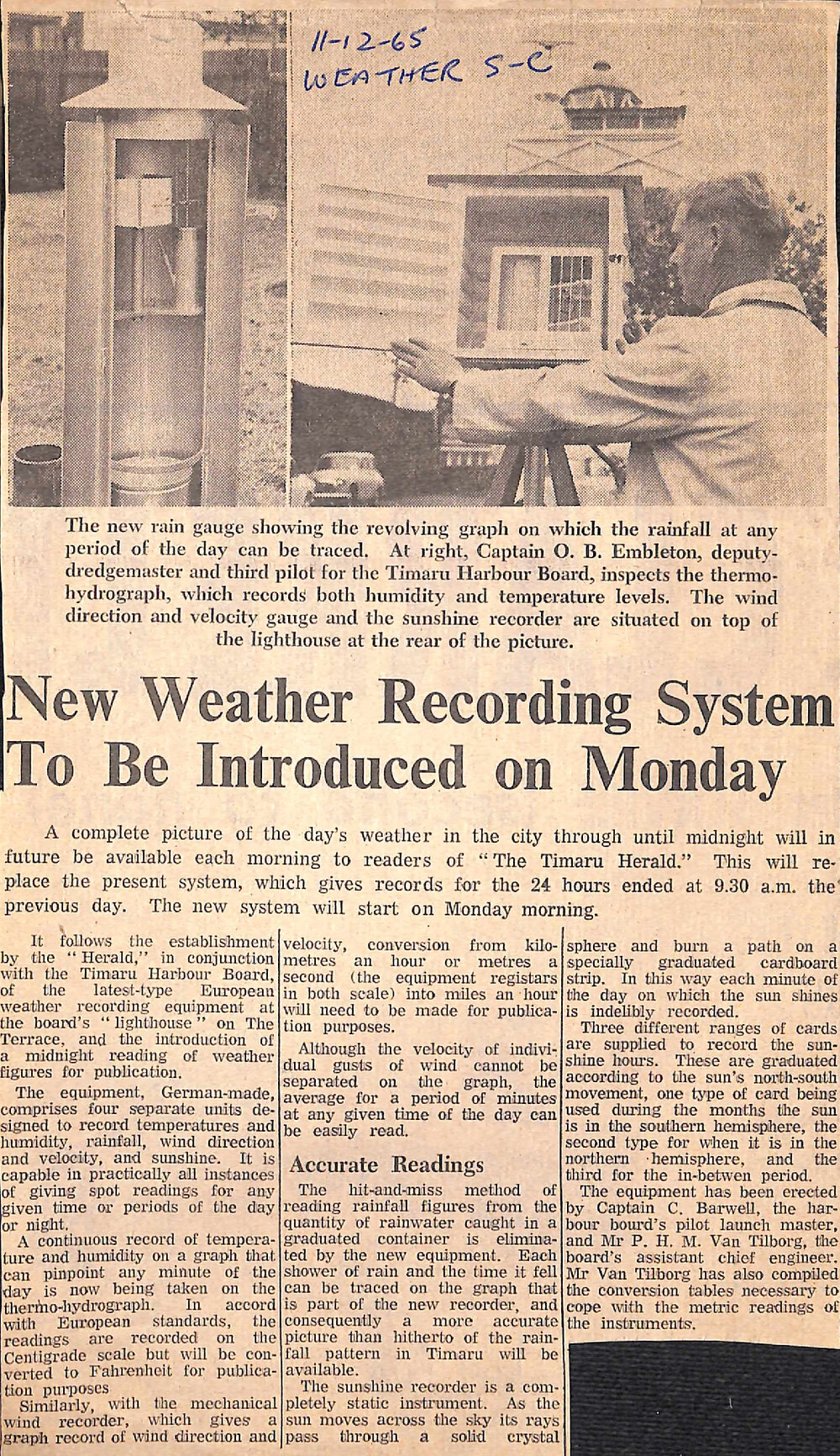
11 Dec 1965 The Timaru Herald New Weather Recording System To Be Introduced on Monday (11 Dec 1965). Aoraki Heritage Collection, https://aorakiheritage.recollect.co.nz/nodes/view/6025
This 1965 article does not prove that the Botanic Gardens tower itself was built in 1965. What it does show is that Timaru’s weather recording was being modernised in 1965. At the port, new German-made recording instruments were installed at the Harbour Board’s lighthouse on The Terrace. The lighthouse itself was much older, dating from the 1870s. If the Botanic Gardens weather tower/station was established in the same year, it may belong to this 1965 modernisation of Timaru’s weather reporting — but the structure would need a separate source to confirm whether it was newly built then or adapted from an older garden feature.
- Before the new system, The Timaru Herald published weather records for the period ending at 9.30 a.m. the previous day.
- The Timaru Herald and the Timaru Harbour Board worked together to establish new European weather recording equipment at the Harbour Board’s “lighthouse” on The Terrace.
- The new system was designed to give readers a more complete picture of Timaru’s weather through until midnight each day.
- The equipment was German-made.
- The system recorded temperature, humidity, rainfall, wind direction, wind velocity and sunshine.
- The new equipment allowed readings to be taken for specific times or periods during the day or night.
- A thermo-hydrograph recorded temperature and humidity continuously on a graph.
- The thermo-hydrograph used the Centigrade scale, with readings converted to Fahrenheit for newspaper publication.
- A mechanical wind recorder produced a graph of wind direction and wind velocity.
- The wind recorder registered in kilometres per hour or metres per second, with readings converted to miles per hour for publication.
- Individual gusts of wind could not be separated on the graph, but average wind speed over a period of minutes could be read.
- The new rain gauge replaced the older method of measuring rainwater collected in a graduated container.
- The rain recorder showed when each shower of rain fell, giving a more accurate picture of rainfall patterns in Timaru.
- The sunshine recorder used a solid crystal sphere to focus sunlight onto a graduated cardboard strip.
- Sunshine was recorded by the sun burning a path onto the strip.
- Different sunshine recording cards were used depending on the seasonal movement of the sun.
- The wind gauge and sunshine recorder were positioned on top of the lighthouse shown in the photograph.
- Captain O. B. Embleton, deputy-dredgemaster and third pilot for the Timaru Harbour Board, is shown inspecting the thermo-hydrograph.
- Captain C. Barwell, the Harbour Board’s pilot launch master, helped erect the equipment.
- Mr P. H. M. Van Tilburg, the Harbour Board’s assistant chief engineer, also helped erect the equipment.
- Mr Van Tilburg prepared the conversion tables needed for the metric readings from the instruments.
- The new weather recording system was due to begin on the following Monday morning.
https://archive.org/details/sails-to-satellites-1986
Publication date 1986 Usage Attribution-NoDerivs 4.0 InternationalCreative Commons Licensebynd Topics New Zealand, Metservice, weather, forecasting, rainfall, James Hector, DSIR, climaate, ozone, data, computers Collection folkscanomy_miscellaneous; folkscanomy
Timeline — from sails to satellites
1642–1643 — Abel Tasman was instructed to note winds, rain and dry weather during his voyage. Weather knowledge in New Zealand began at sea, where storms, winds and safe navigation mattered.
1769–1770 — James Cook’s Endeavour carried scientific instruments, including thermometers and a barometer. Cook recorded New Zealand coastal weather, including severe summer gales.
1840 — A probable tropical cyclone over northern New Zealand was later reconstructed from ship observations. In Sails to Satellites, this is described as New Zealand’s first synoptic weather analysis.
1841 — James Clark Ross established a magnetic and meteorological observatory at the Bay of Islands. Weather observation was already being linked with farming, settlement and practical survival.
1848–1860 — Early weather observations were made by settlers, military officers, harbourmasters and private individuals, but the results were uneven because instruments and observing methods were not yet standardised.
1857 — Captain Byron Drury wrote about New Zealand meteorology and described the Canterbury nor’wester, although he wrongly thought it came from Australia. This is an early written recognition of one of Canterbury’s most distinctive weather patterns.
1860–1861 — Colonel Mould proposed a colonial network of observing stations, including Lyttelton and an inland station near the Southern Alps. In 1861, official meteorological instruments were sent to several centres, including Lyttelton/Christchurch.
1861 — Dr Charles Knight became Director of Meteorological Stations. This is treated as the beginning of New Zealand’s organised official meteorological service.
1862–1863 — Wellington’s observatory began twice-daily observations. Around the same time, John Knowles imagined a storm-warning system using electric telegraphy.
1865–1866 — The Electric Telegraph Act gave central government control of telegraphy. Parliament agreed that the telegraph service could be used for shipping news and weather reports. This was important because weather warnings needed speed.
1869 — Weather was being recorded at 9 a.m. at twenty-six telegraph offices and sent to ports. Harbourmasters and seamen were not fully satisfied, partly because telegraph clerks had many other duties.
May 1874 — Commander R. A. Edwin began experimental storm warnings from the Custom House in Wellington. He became New Zealand’s official weather forecaster.
By the end of 1874 — Daily weather reports were being received from seventeen stations. Timaru is specifically listed as one of those reporting stations, alongside Auckland, Wellington, Oamaru, Port Chalmers, Bluff, Lyttelton and others. This is a key Timaru reference.
1874–1877 — New Zealand had a high number of shipwrecks, with about twenty-five vessels totally wrecked each year. This helps explain why storm warnings mattered so much to exposed ports and coastal towns.
1879–1882 — Intercolonial meteorological conferences encouraged standard observing methods, weather telegraphy and isobaric weather maps. By 1882, newspapers were receiving weather diagrams to help the public understand weather patterns.
1881 — Sir James Hector reorganised meteorological work so New Zealand had one Meteorological Department. There were 37 stations reporting at 9 a.m., warnings were telegraphed to coasts expecting dangerous winds or heavy seas, and weather telegrams were exchanged with Sydney.
1891 and 1907 — Rain-making experiments were tried in North Otago during drought periods, using explosions. In 1907, Bates went to Oamaru as a scientific observer. The trials were judged unsuccessful. This is close regional context for South Canterbury’s later drought and cloud-seeding story.
1908 — Captain Edwin retired after 34 years. By then daily isobaric charts were drawn, forecasts were sent to 62 telegraph offices and eight lighthouses, and local forecasts appeared in newspapers.
1908–1927 — The Revd D. C. Bates became Director. The climatological network included main observing stations and a much larger number of rainfall stations.
1914–1920 — Bates pushed for wireless weather reports from ships. After the First World War, he proposed expanding meteorology for aviation, including better synoptic networks, rainfall stations, mountain stations, kite stations and radio observatories.
1923–1928 — Public radio weather forecasts began to emerge. From 1928, forecasts were broadcast twice daily, and listeners were encouraged to draw their own weather maps.
1926–1927 — The Meteorological Branch moved from the Marine Department to the Department of Scientific and Industrial Research. Dr Edward Kidson became Director in 1927, bringing a stronger scientific and research focus.
1928 — During Kingsford Smith’s trans-Tasman flight, hourly reports were organised from lighthouses, special pilot-balloon flights were made from Christchurch, and weather reports were passed to the aircraft in flight.
1929 — R. G. Simmers, a physics graduate from Canterbury University College, joined the professional staff. Pilot-balloon observations were also made by H. F. Skey of the Christchurch Magnetic Observatory.
1939 — Dr Edward Kidson died suddenly. By this time, the Meteorological Service had grown from a very small staff into an organisation with more than forty staff, including professional meteorologists. Christchurch had become an important regional branch.
1939–1942 — With war looming, the Meteorological Service came under Air Department control. On 1 February 1942, the Service became part of the RNZAF structure.
1943 — Small wartime weather-observing units were established at places including Ashburton and Harewood.
1945 — Wartime meteorological censorship was not fully removed until June 1945. During the war, weather information had been treated as sensitive because it could affect military operations.
1947–1950 — The Meteorological Office became an independent branch of the Air Department. New Zealand was among the original countries ratifying the World Meteorological Organisation convention in March 1950.
1950s–1960s — The Service operated as a semi-autonomous branch of the Air Department, then the Civil Aviation Department. In 1964, the Civil Aviation Act formally identified its functions: public weather service, advancing meteorology, and advising government.
1961–1962 — Television weather forecasts began. The first live Wellington television weather presentation took place in March 1962.
1964 — The first woman observer was appointed after restrictions around women working night shifts eased.
1964–1966 — The Meteorological Service gave funding to the University of Canterbury’s Electrical Engineering Department to develop a prototype satellite receiving system. In 1966, Christchurch used Deep Freeze satellite equipment to obtain regular cloud pictures and send them by facsimile to other meteorological offices.
1966–1985 — The GHOST project operated from Christchurch, using super-pressure balloons to study large-scale atmospheric movement in the Southern Hemisphere.
1968 — The Service became part of the new Ministry of Transport. The same year, the new Kelburn head office opened shortly before the Wahine storm.
1969 — During drought concern, and against the advice of the Meteorological Service, the Government authorised RNZAF cloud seeding in South Canterbury and North Otago. This is the clearest South Canterbury reference in the book.
1970 — Commercial satellite equipment was installed in Wellington and Nandi, improving the ability to detect cloud systems and tropical cyclones.
1975–1977 — Automatic weather station development moved from prototype to pilot network. By 1977, the pilot network of eleven stations was complete.
1978 — The first units of the Meteorological Service computer system were installed. The system helped process satellite data, automatic weather station reports, numerical prediction models and routine forecast work.
1978 — A marine section was set up to handle storm warnings and coastal weather bulletins. This continued the coastal-warning tradition begun by Captain Edwin in 1874 — the same early system that included Timaru as a reporting station.
1979–1982 — A cloud physics programme began. In 1981, the Service bought a sailplane for cloud research, and by 1982 an aircraft was being prepared for cloud physics and atmospheric sampling.
1980 — A new satellite terminal opened at Kelburn. It produced visible and infra-red cloud images, mosaics, vertical profiles, sea-surface and cloud-top temperatures, and data from automatic weather stations.
1982–1985 — Weather maps were increasingly sent by radio facsimile. By 1985, nearly all newspapers included weather maps, mostly transmitted from the National Weather Forecasting Centre.
1984–1986 — Teletext began carrying district, coastal and mountain forecasts in February 1984. By 1986, aircraft satellite data relay systems were expected to contribute to global weather analysis and forecasting.
1985–1986 — De Lisle closed the book by looking back over 125 years of government-funded meteorology: from small, scattered beginnings to a national service of about 350 staff working in a global, satellite-linked weather system.
Local points to pull out
Timaru, 1874 — Timaru was part of Captain Edwin’s early national storm-warning reporting network.
South Canterbury, 1969 — South Canterbury was part of the Government-approved RNZAF cloud-seeding operation during drought concern.
Canterbury more widely — The book also connects Canterbury to the nor’wester, early Lyttelton/Christchurch observing stations, aviation weather, satellite receiving work at the University of Canterbury, Christchurch Deep Freeze satellite equipment, and the GHOST balloon project.