Location: Caroline Bay, central memorial wall and sundial area
Access: Public
Associated years: 1929, 2008 to 2009 interpretive additions
Associated people/groups: Caroline Bay Association, New Zealand Victoria Cross recipients, New Zealand Expeditionary Force, Timaru community
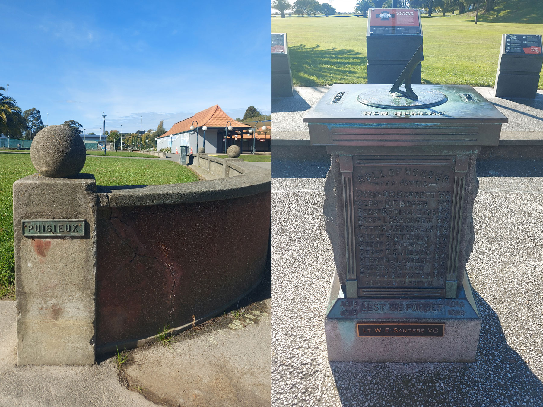
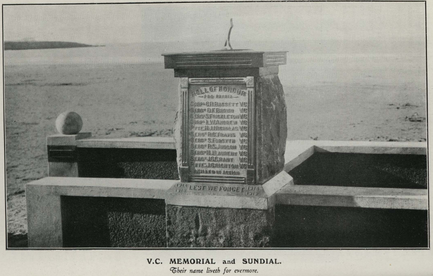
Caroline Bay Memorial Wall is one of Timaru’s most important and unusual war memorial sites. Timaru was very active in creating First World War memorials in the 1920s, and that Caroline Bay’s wall was unusual because it focused on international battle sites and New Zealand VC recipients rather than only local names. You can find the sundial near the centre of the Memorial Wall. The wall links Timaru walkers and visitors to Gallipoli, the Somme, Messines, Passchendaele, Bapaume, and other places where New Zealanders served.
It features the names of WWI New Zealand Victoria Cross medal recipients. A 1929 Aoraki Heritage publication records the Victoria Cross memorial and sundial at Caroline Bay, with information on New Zealand First World War VC recipients.
There are information panels which explain that bronze plaques were installed along the wall on 30 April 1929, naming major First World War battlegrounds, and that a sundial was proposed soon after to commemorate New Zealand Victoria Cross recipients.
This wall is powerful because it does not only list local names. It lists places: Gallipoli, Chunuk Bair, Passchendaele, Messines, the Somme, Palestine, Jutland, Zeebrugge, Ostend and the Falklands. These were the names families read in newspapers and letters. The wall turns a seaside walk into a map of global war. It shows how Timaru remembered the war in a broad national way at this time. The men in the image represent New Zealand’s First World War Victoria Cross recipients, and their names are part of the story told at Caroline Bay.
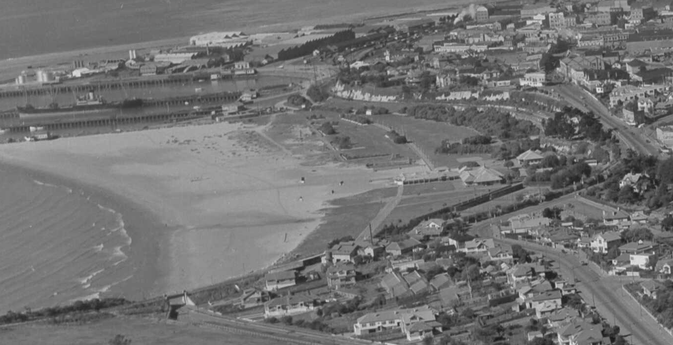
The sea wall might seem like it is a distance from the shore. That is because the sea used to reach this wall, in fact the sea used to be able to reach the cliff. The development at the harbour has impacted the way sediment moves up the coast. Sand was trapped and began to accumulate on what was once a stoney shore. The sand has deposit and built out as a man made sandy bay. The council leased the foreshore from the harbour board and developed it as a port resort.
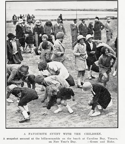
Caroline Bay is one of Timaru’s most layered war-memory sites as it was also a place of carnival, children, music, and seaside leisure. Early Timaru Herald references from 1909 to 1912 describe a merry-go-round operating there, with barrel-organ music, children, council permits, seasonal packing-up, and even complaints that its shrill sounds did not sit comfortably alongside concerts at the rotunda!
This report in old newspaper shows us that the First World War memorial wall was not placed in an empty or solemn landscape. It was built into a place people already associated with summer, crowds, music, play and family life. In 1929, bronze plaques naming major war places were added to the seawall. Names such as Gallipoli, the Somme, Messines, Passchendaele, Palestine, Jutland and Zeebrugge brought the geography of global war into Timaru’s favourite seaside space.
The juxtoposition of play and remembrance says a lot about everyday life at that time. While families walked beside the sea wall, they passed the names of faraway battlefields that had changed local families forever.
This stop on the War Tour can show how Timaru remembered war not only in cemeteries or churches, but in public places where life carried on. The Bay held both joy and grief. It still does.
- 1929: Memorial Wall erected and lawn areas extended.
- 1930: Memorial and sundial added.
- 1941: May: £500,000 given to the Patriotic Fund and War Effort.
- 1941: a bluestone 10-foot-diameter “moon” seat recess was being built south of the viaduct.
- By 20 December 1941, air raid shelters had been built in Station Street, Perth Street, at each end of Caroline Bay, and at other sites around Timaru. It also records that at least 34 shelters appear to have been built in the town, including shelters at schools.
Ways the bay was adapted to prepare for an invasion
- Concrete cylinders laid on their sides in the sand to block potential landing areas
- Obstacles extending from Benvenue cliffs across Caroline Bay to the port
- Anti-tank gates beneath the Virtue Avenue railway bridge
- Barbed wire across the sand, based on local memory
- A gun emplacement at Smithfield
- Showgrounds army camp
- Station Street air raid shelter
- Carnival profits redirected to the Patriotic Fund
- Lighting restrictions and no New Year’s Eve bonfires during wartime carnivals
Find a WuHoo: Choose one plaque and ask: was this a battlefield, a port, a river, a ridge, a naval battle, or a place of training and waiting?
This early map of Timaru from 1911 shows how the sea used to be much closer to the cliffs and how the sea wall at the time of its construction was by the sea shore.
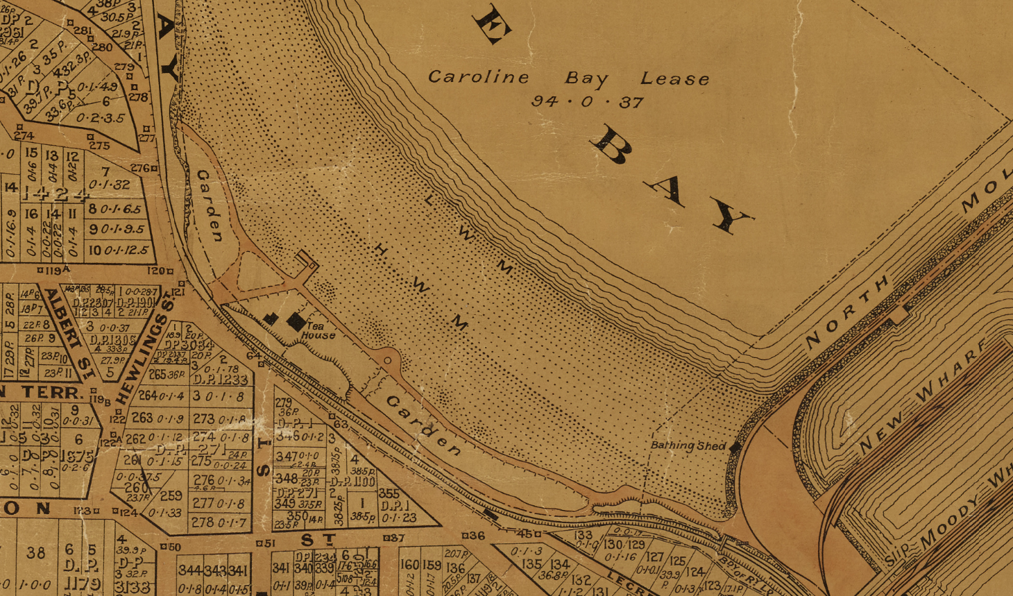
1911. Section of Miscellaneous Plans - Borough of Timaru, South Canterbury. R25538727. Borough of Timaru, South Canterbury. NZ Heritage Maps Platform, https://maps.recollect.co.nz/nodes/view/336
Crop of Caroline Bay to Timaru CBD, South Canterbury Region - National Library 720136
Side Quest: Who Championed the Caroline Bay Victoria Cross Sundial?
The Caroline Bay Victoria Cross Sundial was part of the wider Caroline Bay Memorial Wall project, developed by the Caroline Bay Association in 1929.
The main local champion appears to have been Mr G. S. Cray. At the Caroline Bay Association’s annual meeting in May 1929, Cray explained that a sundial would be placed near the centre of the new wall to commemorate New Zealand soldiers who had received the Victoria Cross during the First World War.
The wider wall and lawn extension work cost the Association £1388. The exact funding for the sundial itself is not fully clear. Cray said he hoped the whole cost would not have to come from Association funds, and that he intended to propose a scheme to help meet the expense.
Local workmanship helped reduce the cost. The Vulcan Foundry in Timaru assisted with the brass name plate, and the Timaru price was reportedly much cheaper than quotes from Dunedin.
By 1930, the Caroline Bay Association credited the memorial to Cray’s “unlimited enthusiasm”. A later report also stated that the sundial itself was made by Mr James Stewart of Invercargill.
This helps explain why the sundial records national Victoria Cross recipients rather than only local men. The Caroline Bay Memorial Wall was not designed as a local roll of honour. Heritage New Zealand describes it as an unusual war memorial because it focused on international battle sites and New Zealand’s role in them, rather than specifically on South Canterbury service.
Visitors' guide to Timaru and Victoria Cross records. Aoraki Heritage Collection, https://aorakiheritage.recollect.co.nz/nodes/view/297 Learn more here: https://digitalnz.org/records/54431764
Summary of information about Timaru's Victoria Cross Recipients from "Visitors' guide to Timaru and Victoria Cross records" published in 1929
This extract records several New Zealand soldiers connected with Victoria Cross actions on the Western Front in 1918.
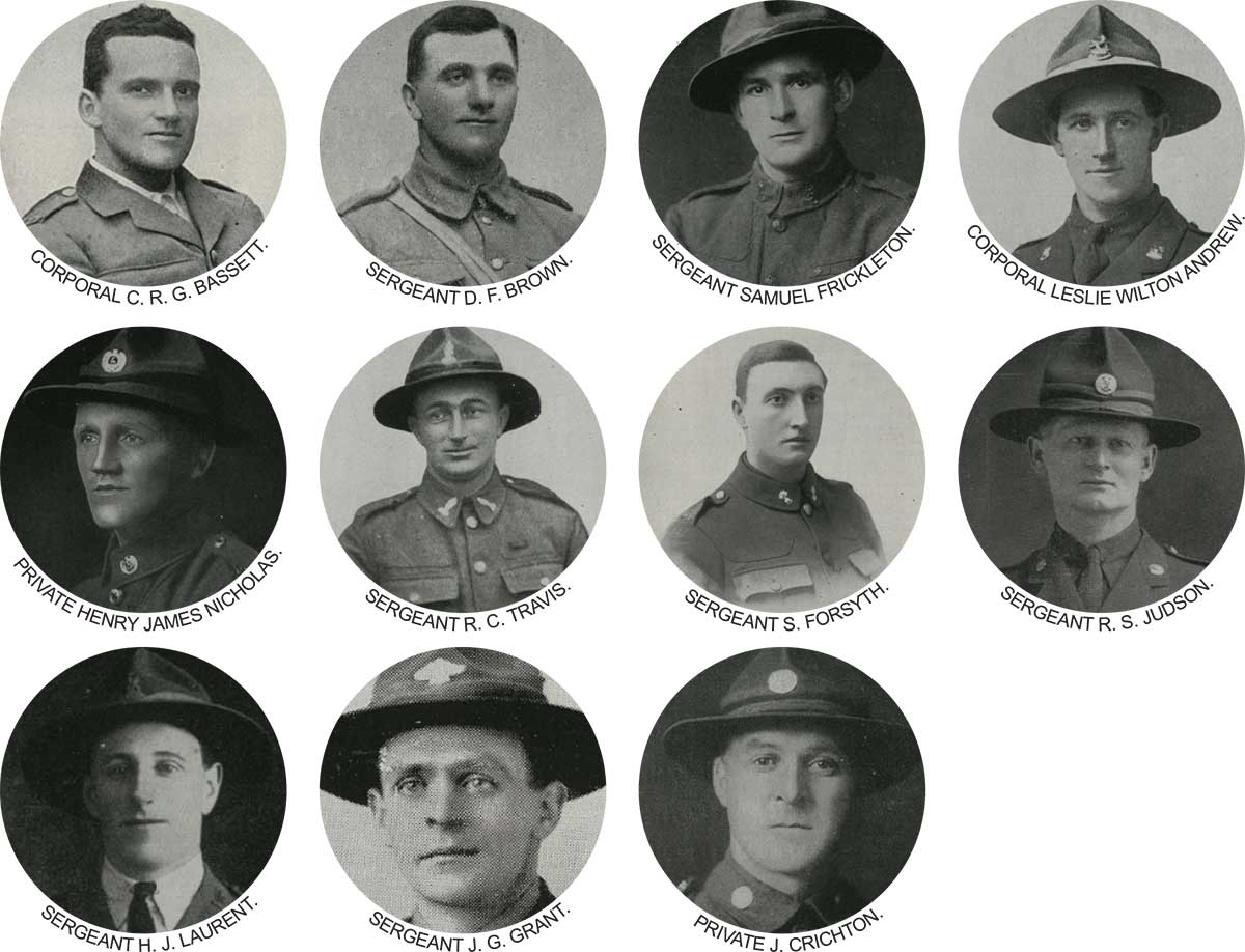
New Zealand Victoria Cross recipients of the First World War
This image shows eleven New Zealand soldiers who received the Victoria Cross for actions during the First World War.
Corporal Cyril Royston Guyton Bassett received the Victoria Cross for his actions at Chunuk Bair, Gallipoli, on 7 August 1915. He and others laid and repaired telephone wire to the front line in daylight under heavy fire. His was the only Victoria Cross awarded to the New Zealand Expeditionary Force during the Gallipoli campaign.
Sergeant Donald Forrester Brown received the Victoria Cross for his actions near Flers, France, on 15 September 1916, during the Battle of the Somme. He charged and captured key enemy machine gun positions, helping New Zealand troops advance. He was killed just over two weeks later and received the award posthumously.
Sergeant Samuel Frickleton received the Victoria Cross for his actions at Messines, Belgium, on 7 June 1917. Although wounded, he went forward under heavy fire and destroyed two machine gun posts with hand grenades, helping his battalion continue the advance.
Corporal Leslie Wilton Andrew received the Victoria Cross for his actions at La Basseville, Belgium, on 31 July 1917. Leading a small group of men, he captured and cleared several German machine gun positions, showing strong leadership and initiative.
Private Henry James Nicholas received the Victoria Cross for his actions at Polderhoek, Belgium, on 3 December 1917. During the attack on Polderhoek Chateau, he single-handedly attacked a German strongpoint, overcoming its defenders and helping the advance.
Sergeant Richard Charles Travis received the Victoria Cross for his actions at Rossignol Wood, France, on 24 July 1918. He destroyed an obstacle blocking the advance, captured enemy machine guns, and helped hold the position. He was killed by shellfire the following day and received the award posthumously.
Sergeant Samuel Forsyth received the Victoria Cross for his actions at Grévillers, France, on 24 August 1918. Although wounded, he helped deal with enemy machine gun fire, worked with a tank crew, and continued leading the attack after the tank was disabled. He was killed by a sniper and received the award posthumously.
Sergeant Reginald Stanley Judson received the Victoria Cross for his actions near Bapaume, France, on 26 August 1918. Leading a small bombing party under heavy fire, he captured enemy machine gun positions and helped the advance continue. He also received the Distinguished Conduct Medal and Military Medal.
Sergeant Henry John “Harry” Laurent received the Victoria Cross for his actions near Gouzeaucourt Wood, France, on 12 September 1918. While leading a patrol behind enemy lines, he organised his men, attacked enemy positions, captured prisoners, and led his patrol safely back.
Sergeant John Gildroy Grant received the Victoria Cross for his actions near Bancourt, France, on 1 September 1918. During the advance near Bapaume, he and another soldier rushed German machine gun positions and helped destroy them. His was the last Victoria Cross awarded to a member of the New Zealand Expeditionary Force for First World War service.
Private James Crichton received the Victoria Cross for his actions at Crèvecoeur, France, on 30 September 1918. Although wounded in the foot, he carried messages under fire, swam the Scheldt River, and removed detonators from mines placed under a bridge. His actions helped save the bridge and allowed the advance to continue.
Together, these men represent some of the most highly recognised acts of courage by New Zealand soldiers during the First World War. Their stories should be remembered with both respect for their bravery and awareness of the terrible cost of the war.
Western Front
France and Flanders
Aisne
A river in France. The Cyclist Battalion and Otago Mounted Rifles were trained near the Aisne with the XXII Corps in 1918.
Albert
A Picardy town close behind the British Zone at the Battle of the Somme in 1916. It was the scene of much fierce fighting and was taken and retaken many times. During these engagements, the town was totally destroyed.
Amiens
A large French city behind the area of the Somme fighting. In March 1918, the German attack drove very near this important railway centre, and both New Zealand and Australian troops played an important part in saving it.
Antwerp
The Belgian port to which a hastily organised expedition was dispatched at the beginning of the war to resist the invasion of this important town. Antwerp fell into the hands of the Germans and was occupied by them throughout the war.
Armentières
An industrial town in northern France. The New Zealand Division that first entered the line in France in May 1916 was quartered in the neighbourhood of this place, and the reserve brigades lived in the town.
Arras
A town in northern France well known for its cloth manufacturing industry. It was close to the front line throughout the war. The New Zealand Tunnelling Corps operated in this locality.
Bapaume
A Picardy town captured by the New Zealand Division in August 1918. This town had been taken by the British during the German retreat to the Hindenburg Line early in 1917 and retaken by the Germans in 1918.
Beauvois
One of the large villages captured by the New Zealand Division in the final advance of October 1918. It is situated on the Cambrai–Le Cateau Road.
Bellvue
Bellvue Spur was the locality where many of the strongest German pillboxes and thickest wire entanglements were situated, causing enormously severe casualties to the 2nd and 3rd New Zealand Brigades in the attack on Passchendaele on 12 October 1917.
Béthune
A town close to the front line, some miles south of Armentières. It is well known to all troops who fought near the Neuve Chapelle, Lens and Loos area.
Basseville
A hamlet just south of Messines where the New Zealand Division, particularly the 2nd Brigade, had a great deal of heavy fighting during the weeks following the Messines battle.
Briastre
A village near Beauvois which the New Zealand Division passed through in the last month of the war during the final advance.
Cambrai
An old and historically famous town in north-west France. It was occupied by the Germans until October 1918, when it was taken by the British. The New Zealand Division advanced within view of Cambrai on this occasion.
Colincamps
A small Picardy village where the leading New Zealand troops sent to assist in stemming the German attack in March 1918 first encountered the enemy, checked him and drove him back.
Courcelles
A village about half a mile from Colincamps where the New Zealand troops saw a good deal of active war service.
Crèvecœur
A village on the Escaut Canal, taken by the New Zealand Division early in October 1918.
Esnes
Captured by the New Zealand Division on 8 October 1918.
Estaires
A town in Flanders well known to the New Zealand troops who served in 1916 and early 1917. It was a reserve billeting area.
Étaples
The base camps for drafts and reinforcements coming from England to join the armies in France were situated here.
Flers
Captured and held by the 3rd New Zealand Rifle Brigade in September 1916. Of this New Zealand Division’s fighting, the Army Commander said in a special order: “Their success in the Flers neighbourhood will rank high among the best achievements of the British Army.”
Fleurbaix
A village south of Armentières which gave the name to a sector where the New Zealand Division held the line during the 1916–1917 winter.
Fricourt
One of the strongly fortified villages in the forward German trench system captured by the British on the opening day of the Battle of the Somme in 1916.
Ginchy
A fortified village around which heavy fighting occurred in the Battle of the Somme in 1916.
Gommecourt
Gommecourt Wood was one of the most elaborately fortified positions in the German trench system during the Battle of the Somme in 1916, and resisted British attacks for many months. In the Somme fighting of 1918, it was in the New Zealand Divisional area.
Havrincourt
Havrincourt Wood was taken by the New Zealand Division in September 1918, during the final series of British advances.
Hébuterne
A village in the Somme area. In its neighbourhood, the New Zealand Division first closed the gap driven by the German attack between the 3rd and 5th British Armies in March 1918.
Herbignies
A small village almost in the Forest of Mormal, taken by the New Zealand Division in its last battle of the war.
Hooge
East of Ypres on the Menin Road. Noted for heavy fighting in its neighbourhood during the war. All New Zealanders passed through Hooge on the way to and from the line during the 1917–1918 winter.
Houplines
A small village immediately north of Armentières. Many New Zealanders did their first term of trench duty just outside this village.
Kemmel
Mount Kemmel is one of the commanding features rising out of the Flanders plains. It afforded an extensive view over all the battle areas from Ypres to Armentières.
La Signy
A farm on the commanding ridge near Hébuterne. A New Zealand attack against this ridge on 30 March 1918 was extraordinarily successful, with over 100 machine guns captured from the enemy with very small loss to the attacking battalions.
Le Cateau
A town in north-west France which gave its name to the battle of 25 August 1914, when the Second British Army Corps under General Smith-Dorrien made its famous stand during the retreat from Mons.
Le Quesnoy
A town with 17th-century fortifications and the last place of any considerable size captured by the New Zealand Division during the war. It was taken by assault with scaling ladders on 4 November 1918, a week before the Armistice.
Lille
A large manufacturing city near the Belgian border in northern France. From Armentières, its factory chimneys could be seen. It was recaptured from the Germans in 1918, but was held by them during the greater part of the war.
Longsart
A hamlet near Esnes, captured in the course of the Somme advance in October 1918.
Loos
A mining town in northern France notable for the great and costly British attack made in 1915, and subsequently the scene of much fighting during the greater part of the war.
Louvain
A Belgian town where notorious atrocities were committed by one of the German divisions during the invasion of Belgium at the beginning of the war.
Marcoing
A village on the Escaut Canal near Masnières, associated with the advance of Auckland and Wellington infantry at the end of September 1918.
Marne
A French river on the line of which the initial German advance in 1914 was checked, and from where the invading armies were pushed back to the Aisne.
Masnières
The New Zealand Division passed close to this village, which is situated on the Escaut Canal a few miles from Cambrai. This was in the advance to Crèvecœur at the end of September 1918.
Messines
A small town situated on a commanding ridge between Ypres and Armentières. The British attack on this ridge on 7 June 1917 was one of the most perfectly prepared operations of the war. On this day, the town was taken by the New Zealand Division.
Meteren
A village near Bailleul, known to the New Zealanders as a back-area village in Flanders. It was taken by the Germans in their Lys attack in April 1918, and the New Zealand Entrenching Battalions suffered heavily in this area.
Miraumont
One of the villages captured by the New Zealand Division at the first outset of the advance to victory in August 1918.
Mons
Famous as the place of the first encounter of the British Expeditionary Forces with the Germans in August 1914.
Nieppe
On the Bailleul–Armentières road, the locality for New Zealand Reserve Battalions during the occupation of the La Bizet sector in June, July and August 1917.
Nieuport
A Belgian coastal town on the extreme northern flank of the Allied line in Flanders.
Passchendaele
A town on the highest part of the ridges overlooking Ypres from the east. In an attack aimed at this place during appalling weather conditions on 12 October 1917, the New Zealand Division suffered its one reverse in a major operation. The progress of the attacking troops was physically impossible, with deep mud and uncut wire entanglements blocking the way. The casualties were extraordinarily heavy: the heaviest experienced by the New Zealand troops during any engagement in France.
Péronne
One of the well-known larger towns in the Somme area. It was taken and retaken several times by the opposing forces.
Ploegsteert
A famous Flanders wood, the scene of much fighting in the early days of the war. It was held by the New Zealand Division from February to August 1917.
Plus Douve
A farm on the western slope of Messines Ridge, taken by the New Zealand Division on 7 June 1917. It is in the vicinity of Hill 63, where much fighting took place.
Polderhoek
A chateau situated on a commanding ridge north of Gheluvelt. It was the objective of a minor operation by the 2nd New Zealand Infantry Brigade in December 1917.
Polygon Wood
A wood east of Ypres. In the fighting of 1917, this wood was completely destroyed by shell fire. Throughout the 1917–1918 winter it was included in the sector held by the New Zealand Division.
Poperinghe
A Belgian town on the main road to Ypres and well known to all troops engaged in the Ypres area throughout the war.
Pozières
One of the fortified villages in the German positions of the first Somme battle in 1916. After resisting a number of attacks, it was finally assaulted and taken by Australian troops.
Pussieux
One of the villages taken by the New Zealand Division in August 1918, during the final advance to victory.
Rheims
A famous French cathedral town which was close to the front line throughout the war and suffered much damage from shell fire.
Rossignol
A wood cleared by the New Zealand Division just prior to the series of advances which ended the war.
Sailly
There are two Saillys well known to New Zealanders: Sailly-sur-la-Lys during Flanders days in 1916 and early 1917, and Sailly-au-Bois, where one of the brigade headquarters was located in the second Somme battles from March to August 1918.
Somme
A river in north-west France which gave the name to the most bitterly contested and prolonged battles of the war, which lasted from July to November 1916, and in the course of which each side suffered approximately half a million casualties.
St Omer
A large railway junction in the war area of the British Army zone in northern France, and at one time the headquarters of the British Expeditionary Forces.
St Quentin
A town of considerable size in north-west France which figured prominently in the history of the war.
St Yves
A hamlet on a small knob just inside the British front line forward of Ploegsteert Wood. It was in the New Zealand sector from February to August 1917.
Thiepval
A strong forward centre of resistance was established by the Germans in this village before the opening of the Battle of the Somme in 1916. It resisted British attacks for many months.
Tourcoing
A manufacturing centre near Lille. It was occupied by the Germans until the last few weeks of the war.
Treścault
A village near Havrincourt Wood. The line of the New Zealand Division’s advance in September 1918 passed close to the right of this place.
Warneton
A hamlet between Messines and the Lys River. The New Zealand Division had some hard fighting here shortly after the Battle of Messines in 1917.
Vimy Ridge
A ridge near Arras, principally noted for the Canadian attack which wrested the ridge from the Germans in April 1917.
Ypres
A famous Belgian city which was entirely destroyed during the war, and in the defence of which the British and Allied armies suffered hundreds of thousands of casualties.
Zonnebeke
A village a short distance east of Ypres, situated within the Ypres Salient.
Eastern Front
Egypt, Gallipoli and Palestine
Egypt
By a strange circumstance, the oldest civilised country on earth was selected as the cradle where volunteer soldiers from the youngest countries were assembled in the service of the greatest Empire that exists or has ever existed. Here, among surroundings that date back thousands of years before the Christian era, Australian and New Zealand troops were joined and trained for the great adventure connected with the invasion of Gallipoli, an adventure that involved great sacrifice of life, thus cementing a unity to be known for all time under the sacred name of ANZAC.
Ismalia
A garrisoned post on the Suez Canal to which New Zealand soldiers were dispatched in January 1915 from Egypt.
Kantara
Another strongly garrisoned post on the Canal to which men from the New Zealand Infantry Regiments were posted, and where they received their baptism of fire on the night of 2 February 1915.
Serapeum
A strongly garrisoned position about 20 miles south of Ismalia and 40 miles south of Kantara. On the night of 2 February 1915, at the same time as the Turks attacked Kantara, an attempt was made to cross the Canal in pontoons. Men belonging to the Nelson Company of the Canterbury Regiment played an important part in defeating this movement, and the enemy was repulsed and suffered heavy loss. The first casualties experienced by the New Zealand forces in the war occurred here: one sergeant of the Nelson Company was wounded and a private died of wounds received in this engagement.
Zeitoun
The military camp in Egypt situated about eight miles from Cairo where the New Zealand troops were trained, and from which the divisions for Gallipoli and Palestine were dispatched on active service.
ANZAC
A name formed from the initial letters of Australian and New Zealand Army Corps. First used, written A. and N.Z.A.C., in Egypt when the Army Corps was formed. It soon became A.N.Z.A.C., and the new word was so obvious that the full stops were omitted. It gave the name to Anzac Cove, a little bay where the principal landing of Australian and New Zealand troops was made on 25 April 1915.
Chunuk Bair
A ridge about 800 feet high on the Sari Bair below Hill Q and above Rhododendron Spur.
Gaba Tepe
A headland about a mile and a quarter south of the Anzac right flank. The Anzac landing was originally known as the Gaba Tepe landing. Most of the earlier gazetted decorations were prefaced “in the neighbourhood of Gaba Tepe”, which really means Anzac.
Gallipoli
The name of the Gallipoli Peninsula is derived from a seaport town of Turkey in Europe at the north-eastern extremity of the Dardanelles, 130 miles south-west of Constantinople. The invasion of Gallipoli, with the object of capturing the Dardanelles, was secretly planned, and the memorable landing of British, Australian and New Zealand troops was made on 25 April 1915. After prolonged fighting, the evacuation of Gallipoli was accomplished in the closing days of that year without a single casualty. The final evacuation of the Peninsula was made at Cape Helles on 9 January 1916, closing one of the most valiant but unsuccessful exploits in the history of the British Empire.
Krithia
In May 1915, reinforcements were landed near Cape Helles, their objective being an attack on Achi Baba through Krithia. Although assisted by a large number of battleships, including the Queen Elizabeth, the vessels storming the hills in protection of the landing forces, the attack proved unsuccessful. The subsequent attack on Krithia was equally futile, and Achi Baba remained impregnable throughout the occupation of Gallipoli.
Quinn’s Post
A famous front-line post at the head of Monash Gully, the salient of the Anzac line. It was named after Major Quinn of the 15th Australian Infantry Brigade, who was killed defending this post.
Sari Bair
The name given to the commanding main feature which lay in front of the troops at Anzac. It consisted of a tangled mass of hills and watercourses inland from Anzac and Suvla, culminating in Hill 971, and was never wrested from the Turks.
Suvla
A bay on the Gallipoli Peninsula to the left of Anzac, from which an attempt to launch new troops against Sari Bair from the left flank ended in failure.
Amman
A Turkish garrison town situated on the Hedjaz Railway. It was strongly held and repulsed an attack of Allied troops in March 1918. The New Zealand Mounted Rifles suffered severely in this attack. It was subsequently captured by General Chaytor’s forces in September 1918.
Es Salt
A town in the mountains of Moab beyond the Jordan, familiar to New Zealand troops during operations against Amman. It was captured in September 1918.
Gaza
A town of 40,000 inhabitants on the Palestine coast. Associated with doings of Samson; it was there he destroyed the temple of Dagon. The New Zealand Mounted Rifles Brigade was associated with other troops in futile attacks in March and April 1917. The city fell to General Allenby in November 1917.
Jaffa
The seaport of Jerusalem. The name means “beautiful”. The town itself does not justify this claim, but the surrounding country does. It surrendered to the New Zealand Mounted Rifles Brigade on 16 November 1917.
Jericho
A town in the Jordan Valley. It surrendered to the Auckland Regiment, New Zealand Mounted Rifles, on 20 February 1918.
Palestine
The homeland of the Jews, under Turkish domination for four centuries until released by victorious Allied troops in December 1917. It was the scene of much fighting by the New Zealand Mounted Rifles Brigade.
Rafa
A Turkish post on the boundary between Egypt and Palestine. It was captured by British forces, of which the New Zealand Mounted Rifles were part, on 9 January 1917.
Baghdad
Capital of Iraq, standing on both banks of the Tigris River and situated about 300 miles from the head of the Persian Gulf. The city is the most famous of any in the Moslem East. It was captured in March 1917 and remained under British control until the end of the war.
Marquette
This tablet commemorates the loss of the Marquette, which was sunk by a German submarine while conveying troops from Egypt to Salonika. The heavy loss of life included a number of New Zealand nurses and other units of the New Zealand Ambulance Brigade.
Mesopotamia
Part of Iraq, Arab territory lying between the Tigris and Euphrates rivers, and the scene of many ancient battles. Operations in this area were conducted by the Indian Government, mainly with Indian native troops. The object of the campaign was to divert the strength of the Turkish defence of Palestine and Gallipoli, and also to protect the highway to India from the Persian Gulf.
Salonika
A great commercial city of Greece and chief European port of the Aegean at the head of the Gulf of Salonika. In 1915 an Anglo-French force landed here, and after the evacuation of Gallipoli and the abdication of King Constantine of Greece, a huge Allied force was collected which finally, in 1918, completely crushed the Bulgarian alliance with Germany.
Naval Engagements
Falkland
Following the destruction by a German squadron of three British armoured cruisers off Coronel, on the coast of Chile, South America, on 1 November 1914, a squadron of British battle-cruisers left Portsmouth secretly and succeeded in reaching the Falkland Islands, the southernmost British possession in the South Atlantic Ocean, without the knowledge of the enemy. The German squadron, which was steaming up from Cape Horn with the object of seizing the Falkland Islands and establishing a base there, was surprised by the British fleet on 8 December 1914. Although the Germans scattered, all save one of their ships were destroyed in a running action, and Coronel was more than avenged.
Jutland
The decisive naval action of the war was fought in the eastern arm of the North Sea off the coast of Jutland, a province of Denmark north of the Kiel Canal. On 31 May 1916, the German High Seas Fleet emerged from Kiel and Wilhelmshaven and was promptly engaged by the British First Battle-Cruiser Squadron, which endeavoured to hold the enemy until the Grand Fleet arrived. The Germans retired in disorder when the heavily armoured British battleships appeared on the horizon. In the intervening hours, both sides had suffered heavy losses, but the German High Seas Fleet was so crippled as to be useless for months afterwards. It did not emerge again while the war lasted, while the British Fleet, after completing with fuel, was ready immediately to fight another action, if this had been offering.
Ostend
A well-known Belgian port and watering place, and the terminus of a great canal system. After being taken by the Germans in August 1914, it was strongly fortified by them and used as a submarine base. In consequence, and also because of its proximity to both France and England, it was closely watched by the Royal Navy’s Dover Patrol throughout the war, and frequently bombarded by monitors protected by destroyers and drifters with submarine nets. It was also raided by special naval detachments.
Zeebrugge
A town and port on the Belgian coast which, though considerably smaller than Ostend, was used by the Germans in a similar way, and by 1916 had become their principal submarine base for attacking British commerce. Like Ostend, it was closely watched by the Dover Patrol of the Royal Navy throughout the war and bombarded at regular intervals. On 22 April 1918, a specially recruited volunteer naval detachment, in the course of a thrilling action, landed on the pier, and there was considerable hand-to-hand fighting while the Patrol itself successfully blocked the channel to the port by sinking H.M.S. Vindictive and other old vessels in the fairway, thus putting Zeebrugge out of action as a submarine base.
Sources
1. Timaru Herald, 30 May 1929, “Caroline Bay Association”
Used for: Caroline Bay Association annual meeting, £1388 cost, G. S. Cray’s role, plan for the sundial, uncertainty over funding, and Vulcan Foundry assistance.
https://paperspast.natlib.govt.nz/newspapers/THD19290530.2.46
2. Star (Christchurch), 21 May 1930, “Timaru News”
Used for: the 1930 report crediting G. S. Cray’s “unlimited enthusiasm”, local production of the brass base and plate, James Stewart of Invercargill making the sundial, and the claim that Timaru had the only memorial to New Zealand VC heroes then existing in the Dominion.
https://paperspast.natlib.govt.nz/newspapers/TS19300521.2.38
3. Heritage New Zealand Pouhere Taonga, “Caroline Bay Memorial Wall”
Used for: the wider heritage context, including that the wall functioned as both a sea wall and First World War memorial, and that it was unusual because it focused on international battle sites and New Zealand Victoria Cross recipients rather than specifically local South Canterbury service.
https://www.heritage.org.nz/list-details/9072/Caroline-Bay-Memorial-Wall
4. Aoraki Heritage Collection, “Visitors’ guide to Timaru and Victoria Cross records”
Used for: evidence that the 1929 guide connected Timaru, Caroline Bay, the Victoria Cross memorial, and the New Zealand First World War VC recipients commemorated there.
https://aorakiheritage.recollect.co.nz/nodes/view/297
5. Aoraki Heritage Collection, “Caroline Bay Victoria Cross sundial”
Used for: photographic record of the sundial at Caroline Bay, including its location along the Memorial Wall and its connection to First World War New Zealand VC recipients.
https://aorakiheritage.recollect.co.nz/nodes/view/4913
Source for the men named on the sundial
6. NZHistory, “NZ Victoria Cross recipients”
Used for: checking names, action dates, places, award dates, and summaries for New Zealand Victoria Cross recipients.
https://nzhistory.govt.nz/page/nz-victoria-cross-recipients
7. Te Ara, “Awards to New Zealand Servicemen”
Useful cross-check for First World War New Zealand VC recipients, ranks, units, action dates, places, and award dates.
https://teara.govt.nz/en/1966/victoria-cross/page-3
Early merry-go-round references from Timaru Herald, 29 October 1909, 29 March 1910, 12 April 1910, 16 May 1911, 22 February 1912, 27 February 1912, 12 March 1912 and 1 November 1912; memorial wall context from Caroline Bay heritage records and the 1929 memorial wall material.