Location: Station Street clay bank, Timaru
Access: Public view only; do not enter unless authorised
Associated years: 1941, 1942, 1944
Associated people/groups: Timaru Borough Council, engineer Robert Comrie, local civilians
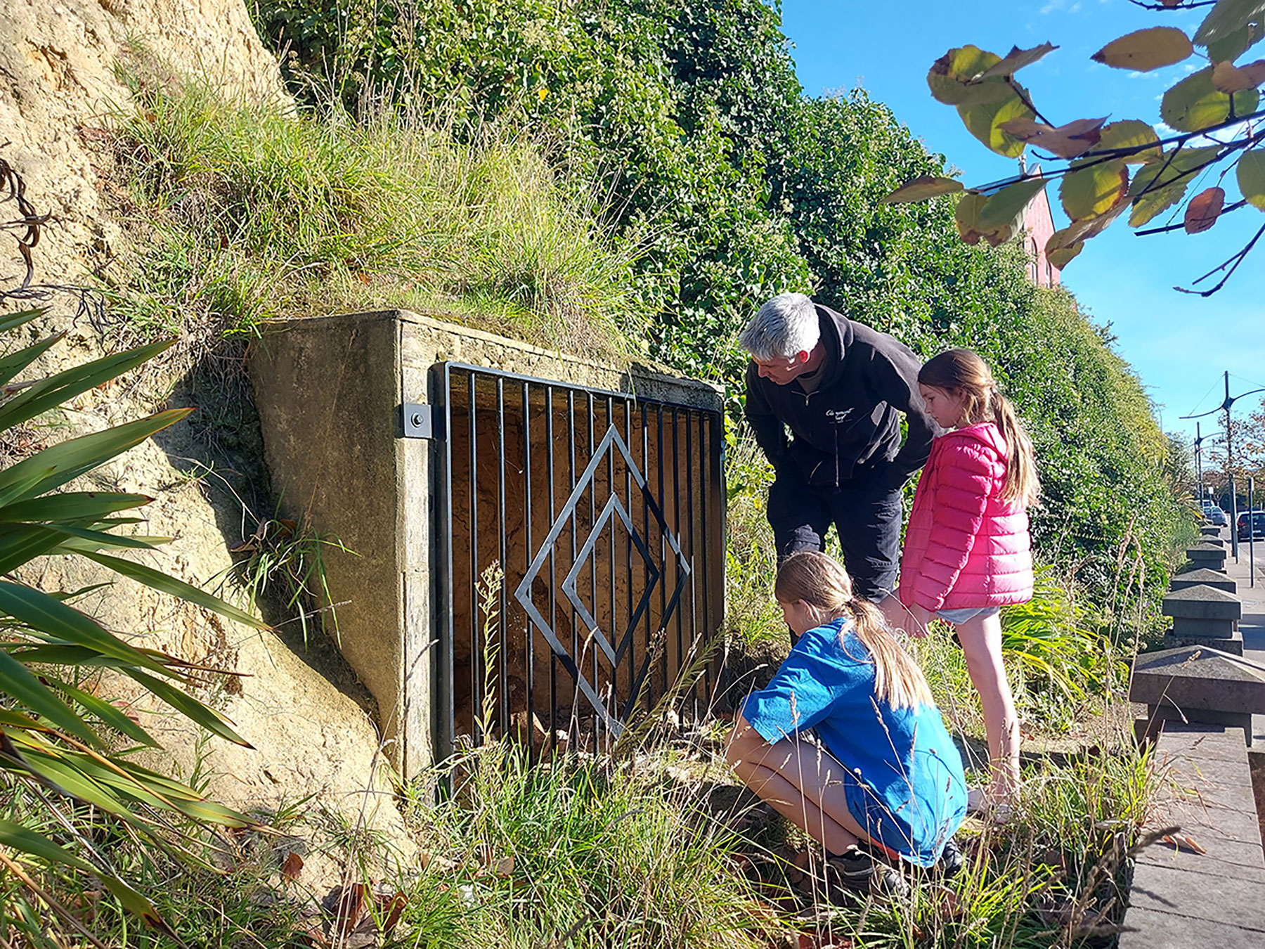
The Station Street shelter is a rare surviving public air raid shelter. Timaru District Council’s heritage assessment says classifies the shelter as Heritage Category A. shelters were already built in several Timaru locations by 20 December 1941, and that no new shelters were built after 1942. As the invasion threat receded, the council resolved to seal the Station Street shelter in March 1944, which helped preserve it while many others were filled in.
Its location was close to the town centre, railway station and Port of Timaru. This is one of the clearest places where the tour can say: war was not only overseas. In 1941 and 1942, Timaru prepared for attack.
In 1915, Timaru Borough Council bought the Scott Bros. electricity generator. By 1916 another generator was installed and about 580 customers had signed up. By 1940, Stafford Street received a new, modern street-lighting system, switched on for the first time on 7 August 1940. During WWII, street lights became a blackout issue. In 1941 the Borough Electrical Engineer warned that normal street lights caused sky glow and could be seen from the open sea. there were nearly 1100 lamps in the borough and it was estimated thta 600 of them would require shading. Special shades were suggested and experimented with. the first six lights up Wai-iti Road were shaded as an experiment. They also experimented with dimming the internal lights on buses and tried using blue maps. The best solution they found was to put lights under the seats and screen the drivers ticket lamp. They looked into taking coca tins, putting holes in the bottom and placing them over the slot telephones to screen their light. - https://paperspast.natlib.govt.nz/newspapers/THD19410325.2.28
Find a WuHoo: Look at the clay bank. Ask who would have gone inside, how quickly, and what they feared.
Fun Facts:
- The heritage item is the former World War II Timaru Borough Council Public Air Raid Shelter.
- It is located on Station Street, Timaru.
- The site is also identified as 23 Cains Terrace, Timaru.
- The District Plan item number is HHI82.
- The legal description is Lot 2 DP 80381.
- The valuation number is 250008000.
- The shelter was constructed in 1941.
- The shelter was designed or built under R. J. Comrie, the Timaru Borough Council engineer.
- The shelter is utilitarian in style.
- The shelter is approximately 18 metres long.
- The tunnel was dug into a clay bank.
- The shelter has three entries.
- The entries are set at right angles to the main shelter tunnel.
- The entries are screened by metal grilles.
- There is a boundary wall with brick panels opposite the shelter entries.
- The shelter is made from clay, metal, concrete and brick.
- Any additions or alterations to the shelter are unknown.
- The shelter runs parallel to Station Street on its western side.
- The shelter appears to be partly within the road reserve.
- The shelter also appears to extend beneath the car park at 23 Cains Terrace.
- The former Canterbury Farmers’ Co-operative Association buildings are directly north of the shelter.
- The former Customhouse is further north of the shelter.
- Timaru Railway Station is south-east of the shelter.
- The Port of Timaru is east of the shelter.
- By 20 December 1941, air raid shelters had been constructed in several parts of Timaru.
- Shelters had been built in Station Street.
- Shelters had been built in Perth Street.
- Shelters had been built at each end of Caroline Bay.
- Shelters had also been built at other sites around Timaru.
- Some shelters were built at local schools.
- At least 34 air raid shelters appear to have been built in Timaru.
- The shelters were part of a nationwide air raid shelter construction programme.
- The national construction programme took place in late 1941 and early 1942.
- The bombing of Pearl Harbour occurred on 7 December 1941.
- The bombing of Pearl Harbour likely sped up the construction of public and private air raid shelters in New Zealand.
- Some shelters, including the Station Street shelter, were already in place before the Pearl Harbour attack.
- No new air raid shelters were built in Timaru after 1942.
- In March 1944, the Timaru Borough Council decided to seal the Station Street shelter.
- The council considered possibly using the site as a car park in the future.
- The sealing of the Station Street shelter helped preserve it.
- Other Timaru air raid shelters were filled in during late 1943 and early 1944.
- The Station Street shelter remains much as it was built.
- Water and silt have reduced the internal height of the shelter over time.
- The shelter has high historical and social significance.
- The shelter is associated with Timaru’s preparation for possible foreign invasion during World War II.
- The shelter appears to be a rare surviving example of a stand-alone public air raid shelter built by a local council.
- The shelter has cultural significance and valued as a local historic place.
- The shelter is regarded as a place of community identity and public esteem.
- The shelter demonstrates aspects of life in Timaru during World War II.
- The ornamental treatment of the entry grilles contributes to its aesthetic value.
- The adjacent boundary wall contributes to the historic character of the streetscape.
- Its technological and craftsmanship significance relates to its excavation, construction and detailing.
- R. J. Comrie was appointed engineer to Timaru Borough Council in January 1940. He had previously worked for Dunedin City Council’s Works Department. He was engineer in charge of the northern division of Dunedin City Council’s Works Department.
- Although the shelter was built after 1900, the site may have archaeological value.
- The extent of the setting is limited to the tunnel shelter and the entries off Station Street. The western boundary is subject to survey.
SOURCE
https://www.timaru.govt.nz/__data/assets/pdf_file/0011/673904/Historic-Heritage-Assessment-Report-HHI82-Former-World-War-II-Timaru-Borough-Council-Public-Air-Raid-Shelter-Category-A-NEW.pdf
Side Quest: The War Years, 1939 to 1945
By 1940, South Canterbury’s electricity network was beginning to show the strain.
The original lines had been lightly built, and for many years there had been no serious attempt to reconstruct them. There were a few reasons for this. One was the way electricity was used in South Canterbury homes. Because the district had a moderately cold winter climate, electric ranges were not taken up as quickly here as they were in other parts of New Zealand, especially in the North Island.
The figures tell the story. In 1930, electric ranges made up 15.56 per cent of domestic consumers in South Canterbury, compared with 9.14 per cent across New Zealand. But by 1950, South Canterbury had risen only to 27.73 per cent, while the national figure had reached 46.60 per cent.
Another challenge was financial. Timaru was not included in the Board’s retail distribution system, which meant the Board missed out on the advantages of supplying electricity within a more densely populated town area. Rural supply was more expensive to build and maintain, yet the Board was under pressure to keep its tariffs close to Timaru’s lower city rates.
By 1940, it was clear the existing lines would need to be upgraded to meet growing demand. But by then the Second World War had begun. Labour and materials were hard to obtain, and reconstruction on any realistic scale became impossible.
Wartime controls made the situation even harder. Supply authorities needed permission from the Electricity Controller before using construction materials, and the manufacture of many electrical appliances was restricted because raw materials were needed for the war effort.
By 1944, line losses had become a serious problem. Demand from consumers was increasing, but this created an even greater strain at the Grants Hill point of supply. Possible solutions included a second supply point near Studholme, perhaps a third between Temuka and Geraldine, and heavier electric lines.
But until the war ended, there was little that could be done.
Source: 50 years of electricity of South Canterbury. Aoraki Heritage Collection, accessed 15/05/2026, https://aorakiheritage.recollect.co.nz/nodes/view/8351